
চিত্ৰ:European settlements in India 1501-1739.png

এই খচৰাৰ আকাৰ: 800 × 491 পিক্সেল. আন ৰিজ'লিউশ্যনসমূহ: 320 × 196 পিক্সেল | 640 × 393 পিক্সেল | 1,140 × 700 পিক্সেল।
মূল ফাইল (1,140 × 700 পিক্সেল, ফাইলৰ মাত্ৰা: 168 KB, MIME প্ৰকাৰ: image/png)
| এই ফাইলটো ৱিকিমিডিয়া কমন্সৰ পৰা আমদানি কৰা হৈছে। ফাইল বিৱৰণ পৃষ্ঠাৰ সবিশেষ তথ্য তলত উল্লেখ কৰা হ’ল ।
|
সাৰাংশ
| বিৱৰণ |
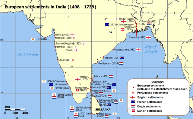
English: Map of India with Sri Lanka, illustrating locations of European settlements in the subcontinent between 1501 and 1739.
Norsk nynorsk: Kart over Sør-Asia med europeiske koloniar/busetjingar mellom 1501 og 1739.
Dansk: Kort af Indien inkl. Sri Lanka med europæiske kolonier mellem 1501 og 1739. |
| তাৰিখ | uploaded in 2006 |
| উৎস |
Self-published work by Luis wiki Map reference: [1] at w:University of Pennsylvania, with reference varification from: [2] (URL accessed: 23-Mar-2006) |
| লেখক | Luis wiki |
| অন্যান্য সংস্কৰণ |
|

![[1]](http://www.history.upenn.edu/coursepages/hist086/material/schmidt26a.jpg)

|
This map of asia image could be re-created using vector graphics as an SVG file. This has several advantages; see Commons:Media for cleanup for more information. If an SVG form of this image is available, please upload it and afterwards replace this template with
{{vector version available|new image name}}.
It is recommended to name the SVG file “European settlements in India 1501-1739.svg”—then the template Vector version available (or Vva) does not need the new image name parameter. |
অনুজ্ঞাপত্ৰ
মই, এই কামৰ স্বত্বাধিকাৰী, ইয়াৰ দ্বাৰা মই এই কামক তলত বৰ্ননা দিয়া অনুজ্ঞাপত্ৰৰ অধীনত প্ৰকাশ কৰিলো:
This file is licensed under the Creative Commons Attribution-Share Alike 2.5 Generic license.
- আপুনি স্বাধীনভাৱে:
- বিতৰণ কৰিব পাৰে – কামটো নকল (কপি), বিতৰণ আৰু প্ৰেৰণ কৰিবলৈ
- পুনৰ্মিশ্ৰণ কৰিবলৈ – কামটো অভিযোজন কৰিবলৈ
- তলত উল্লেখ কৰা চৰ্ত্তসমূহৰ ভিত্তিত:
- স্বীকৃতিপ্ৰদান – আপুনি প্ৰয়োজনীয় স্বীকৃতি দিয়াৰ লগতে অনুজ্ঞাপত্ৰলৈ লিংক আৰু কোনো সালসলনিৰ ইংগিত দিব লাগিব। আপুনি এয়া উপযুক্ত ধৰণেৰে দিব পাৰে, মাত্ৰ অনুজ্ঞাপত্ৰধাৰীয়ে আপোনাক বা আপোনাৰ কামক মঞ্জুৰী জনোৱাৰ দৰে নিলিখিব।
- একে ধৰণে চেয়াৰ কৰক – যদি আপুনি এই কামটো পৰিবৰ্তন, ৰূপান্তৰ বা এই কামটোৰ উপৰত ভিত্তি কৰি নতুন সৃষ্টিকৰ্ম তৈয়াৰ কৰে, আপুনি শেষৰ কৰ্মটো পূৰ্বৰ কৰ্মটোৰ সৈতে একে বা একেধৰণৰ অনুজ্ঞাপত্ৰৰ আওতাত বিতৰণ কৰিব পাৰে।
ফাইলৰ ইতিবৃত্ত
ফাইলৰ আগৰ অৱস্থা চাবলৈ সেই তাৰিখ/সময়ত ক্লিক কৰক।
| তাৰিখ/সময় | ক্ষুদ্ৰ প্ৰতিকৃতি | আকাৰ | সদস্য | মন্তব্য | |
|---|---|---|---|---|---|
| বৰ্তমান | 14:47, 12 March 2011 | | 1,140 × 700 (168 KB) | Luis wiki | Bombay, Portuguese from 1534, later on British |
| 22:30, 5 February 2011 |  | 1,140 × 700 (198 KB) | Henry Bottomley~commonswiki | Title date (see Calicut), Goa date, Flags of the time of Portugal, France and England | |
| 20:49, 2 March 2010 |  | 1,140 × 700 (158 KB) | Brianski | Fix spelling of "Portuguese" | |
| 20:34, 22 February 2007 |  | 1,140 × 700 (214 KB) | Wereon | "CE" unnecessary | |
| 12:32, 23 March 2006 |  | 1,140 × 700 (232 KB) | Miljoshi | Map of India with Sri Lanka, illustrating locations of European settlements in the subcontinent between 1501 and 1739 CE. Category:India |
ফাইল ব্যৱহাৰ
তলত দিয়া পৃষ্ঠাটোৱে এই ফাইলটো ব্যৱহাৰ কৰে:
ফাইলৰ গোলকীয় ব্যৱহাৰ
তলত দিয়া আন ৱিকিসমূহে এই ফাইলটো ব্যৱহাৰ কৰে:
- af.wikipedia.org-ৰ ব্যৱহাৰ
- ar.wikipedia.org-ৰ ব্যৱহাৰ
- ast.wikipedia.org-ৰ ব্যৱহাৰ
- azb.wikipedia.org-ৰ ব্যৱহাৰ
- az.wikipedia.org-ৰ ব্যৱহাৰ
- bn.wikipedia.org-ৰ ব্যৱহাৰ
- br.wikipedia.org-ৰ ব্যৱহাৰ
- ca.wikipedia.org-ৰ ব্যৱহাৰ
- cs.wikipedia.org-ৰ ব্যৱহাৰ
- da.wikipedia.org-ৰ ব্যৱহাৰ
- da.wikibooks.org-ৰ ব্যৱহাৰ
- de.wikipedia.org-ৰ ব্যৱহাৰ
- el.wikipedia.org-ৰ ব্যৱহাৰ
- en.wikipedia.org-ৰ ব্যৱহাৰ
- eo.wikipedia.org-ৰ ব্যৱহাৰ
- es.wikipedia.org-ৰ ব্যৱহাৰ
এই ফাইলটোৰ অধিক গোলকীয় ব্যৱহাৰ চাওক।