
চিত্ৰ:Arunachal Pradesh locator map.svg

মূল ফাইল (SVG ফাইল, সাধাৰণতঃ 2,393 × 1,956 পিক্সেল, ফাইল মাত্ৰা: 263 KB)
| এই ফাইলটো ৱিকিমিডিয়া কমন্সৰ পৰা আমদানি কৰা হৈছে। ফাইল বিৱৰণ পৃষ্ঠাৰ সবিশেষ তথ্য তলত উল্লেখ কৰা হ’ল ।
|
| শিৰোনাম |
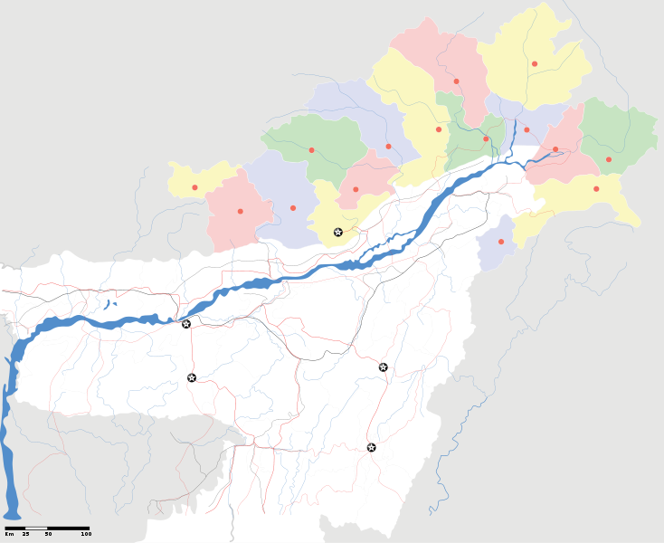
Arunachal Pradesh locator Map. Coordinates: top=29.49, bottom=23.74, left=89.61, right=97.52. |
||
| Description |
Map of w:Arunachal Pradesh with road and rail lines |
||
| তাৰিখ | |||
| উৎস |
নিজা কাৰ্য |
||
| স্ৰষ্টা |
|
||
| অনুমতি (এই ফাইলৰ পুনঃব্যৱহাৰ) |
মই, এই কামৰ স্বত্বাধিকাৰী, ইয়াৰ দ্বাৰা মই এই কামক তলত বৰ্ননা দিয়া অনুজ্ঞাপত্ৰৰ অধীনত প্ৰকাশ কৰিলো: এই ফাইলটো ক্ৰিয়েটিভ কমন্স এট্ৰিবইউচন-চেয়াৰ এলাইক ৩.০ আন্প'ৰ্টেড অনুজ্ঞাপত্ৰৰ অধীনত।
|
||
| Geotemporal data | |||
| Date depicted | second half of 20 century আৰু 21 century | ||
| Georeferencing | If inappropriate please set warp_status = skip to hide. | ||
| Archival data | |||
| টোকা | Part of WikiProject India Maps | ||
derivative works
Derivative works of this file: India Arunachal Pradesh location map.svg
ফাইলৰ ইতিবৃত্ত
ফাইলৰ আগৰ অৱস্থা চাবলৈ সেই তাৰিখ/সময়ত ক্লিক কৰক।
| তাৰিখ/সময় | ক্ষুদ্ৰ প্ৰতিকৃতি | আকাৰ | সদস্য | মন্তব্য | |
|---|---|---|---|---|---|
| বৰ্তমান | 19:04, 16 April 2007 | | 2,393 × 1,956 (263 KB) | Planemad | {{WikiProject_India_Maps |Title=Arunachal Pradesh locator Map |Description=Map of w:Arunachal Pradesh with road and rail lines |Source= [http://www.iitg.ernet.in/rcilts/assam_political.jpg IIT Guwahati - Assam Political map], [http://arunachalgovernor |
ফাইল ব্যৱহাৰ
তলত দিয়া 13 পৃষ্ঠাবোৰে এই ফাইলটো ব্যৱহাৰ কৰে:
ফাইলৰ গোলকীয় ব্যৱহাৰ
তলত দিয়া আন ৱিকিসমূহে এই ফাইলটো ব্যৱহাৰ কৰে:
- ast.wikipedia.org-ৰ ব্যৱহাৰ
- awa.wikipedia.org-ৰ ব্যৱহাৰ
- ba.wikipedia.org-ৰ ব্যৱহাৰ
- ca.wikipedia.org-ৰ ব্যৱহাৰ
- ceb.wikipedia.org-ৰ ব্যৱহাৰ
- de.wikipedia.org-ৰ ব্যৱহাৰ
- dty.wikipedia.org-ৰ ব্যৱহাৰ
- dv.wikipedia.org-ৰ ব্যৱহাৰ
- en.wikipedia.org-ৰ ব্যৱহাৰ
- es.wikipedia.org-ৰ ব্যৱহাৰ
- fa.wikipedia.org-ৰ ব্যৱহাৰ
- fr.wikipedia.org-ৰ ব্যৱহাৰ
- hif.wikipedia.org-ৰ ব্যৱহাৰ
- hi.wikipedia.org-ৰ ব্যৱহাৰ
- hr.wikipedia.org-ৰ ব্যৱহাৰ
- id.wikipedia.org-ৰ ব্যৱহাৰ
- incubator.wikimedia.org-ৰ ব্যৱহাৰ
- ja.wikipedia.org-ৰ ব্যৱহাৰ
- ka.wikipedia.org-ৰ ব্যৱহাৰ
- kbd.wikipedia.org-ৰ ব্যৱহাৰ
- mai.wikipedia.org-ৰ ব্যৱহাৰ
- ml.wikipedia.org-ৰ ব্যৱহাৰ
- ms.wikipedia.org-ৰ ব্যৱহাৰ
- new.wikipedia.org-ৰ ব্যৱহাৰ
- nl.wikipedia.org-ৰ ব্যৱহাৰ
- oc.wikipedia.org-ৰ ব্যৱহাৰ
- or.wikipedia.org-ৰ ব্যৱহাৰ
- pam.wikipedia.org-ৰ ব্যৱহাৰ
- pnb.wikipedia.org-ৰ ব্যৱহাৰ
- pt.wikipedia.org-ৰ ব্যৱহাৰ
- qu.wikipedia.org-ৰ ব্যৱহাৰ
- sat.wikipedia.org-ৰ ব্যৱহাৰ
এই ফাইলটোৰ অধিক গোলকীয় ব্যৱহাৰ চাওক।