
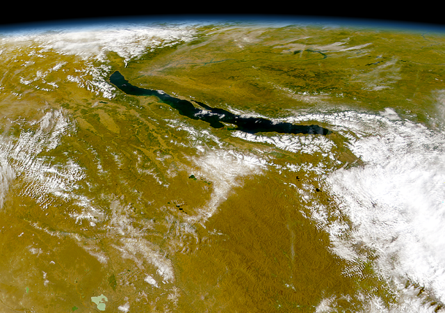
চিত্ৰ:Baikal-S1999276045323.png

এই খচৰাৰ আকাৰ: 800 × 563 পিক্সেল. আন ৰিজ'লিউশ্যনসমূহ: 320 × 225 পিক্সেল | 640 × 450 পিক্সেল | 1,024 × 720 পিক্সেল | 1,220 × 858 পিক্সেল।
মূল ফাইল (1,220 × 858 পিক্সেল, ফাইলৰ মাত্ৰা: 1.9 MB, MIME প্ৰকাৰ: image/png)
| এই ফাইলটো ৱিকিমিডিয়া কমন্সৰ পৰা আমদানি কৰা হৈছে। ফাইল বিৱৰণ পৃষ্ঠাৰ সবিশেষ তথ্য তলত উল্লেখ কৰা হ’ল ।
|
| বিৱৰণ |
Čeština: Bajkal
|
||||
| তাৰিখ | |||||
| উৎস | http://visibleearth.nasa.gov/view_rec.php?id=1002 - http://visibleearth.nasa.gov/images/1002/S1999276045323.png | ||||
| লেখক | Provided by the SeaWiFS Project, NASA/Goddard Space Flight Center, and ORBIMAGE | ||||
| অনুমতি (এই ফাইলৰ পুনঃব্যৱহাৰ) |
|
ফাইলৰ ইতিবৃত্ত
ফাইলৰ আগৰ অৱস্থা চাবলৈ সেই তাৰিখ/সময়ত ক্লিক কৰক।
| তাৰিখ/সময় | ক্ষুদ্ৰ প্ৰতিকৃতি | আকাৰ | সদস্য | মন্তব্য | |
|---|---|---|---|---|---|
| বৰ্তমান | 03:57, 21 July 2005 | | 1,220 × 858 (1.9 MB) | Bdk | Lake Baikal *Source: http://visibleearth.nasa.gov/view_rec.php?id=1002 - http://visibleearth.nasa.gov/images/1002/S1999276045323.png *Sensor OrbView-2/SeaWiFS *Dates: Datastart 1999-10-03 - Visualization Date 1999-10-03 *Visible Earth v1 ID 3678 *Credit: |
ফাইল ব্যৱহাৰ
তলত দিয়া পৃষ্ঠাটোৱে এই ফাইলটো ব্যৱহাৰ কৰে:
ফাইলৰ গোলকীয় ব্যৱহাৰ
তলত দিয়া আন ৱিকিসমূহে এই ফাইলটো ব্যৱহাৰ কৰে:
- arz.wikipedia.org-ৰ ব্যৱহাৰ
- ast.wikipedia.org-ৰ ব্যৱহাৰ
- az.wikipedia.org-ৰ ব্যৱহাৰ
- be.wikipedia.org-ৰ ব্যৱহাৰ
- ca.wikipedia.org-ৰ ব্যৱহাৰ
- ce.wikipedia.org-ৰ ব্যৱহাৰ
- crh.wikipedia.org-ৰ ব্যৱহাৰ
- cs.wikipedia.org-ৰ ব্যৱহাৰ
- cy.wikipedia.org-ৰ ব্যৱহাৰ
- de.wikipedia.org-ৰ ব্যৱহাৰ
- de.wikivoyage.org-ৰ ব্যৱহাৰ
- de.wiktionary.org-ৰ ব্যৱহাৰ
- diq.wikipedia.org-ৰ ব্যৱহাৰ
- el.wikipedia.org-ৰ ব্যৱহাৰ
- en.wikipedia.org-ৰ ব্যৱহাৰ
- eo.wikipedia.org-ৰ ব্যৱহাৰ
- es.wikipedia.org-ৰ ব্যৱহাৰ
- eu.wikipedia.org-ৰ ব্যৱহাৰ
- fa.wikipedia.org-ৰ ব্যৱহাৰ
- fr.wikivoyage.org-ৰ ব্যৱহাৰ
- ga.wikipedia.org-ৰ ব্যৱহাৰ
- he.wikipedia.org-ৰ ব্যৱহাৰ
- hr.wikipedia.org-ৰ ব্যৱহাৰ
- hu.wikipedia.org-ৰ ব্যৱহাৰ
- hy.wikipedia.org-ৰ ব্যৱহাৰ
- it.wikipedia.org-ৰ ব্যৱহাৰ
- ja.wikipedia.org-ৰ ব্যৱহাৰ
- ka.wikipedia.org-ৰ ব্যৱহাৰ
- kbp.wikipedia.org-ৰ ব্যৱহাৰ
- kk.wikipedia.org-ৰ ব্যৱহাৰ
- lb.wikipedia.org-ৰ ব্যৱহাৰ
- lmo.wikipedia.org-ৰ ব্যৱহাৰ
- lv.wikipedia.org-ৰ ব্যৱহাৰ
- mhr.wikipedia.org-ৰ ব্যৱহাৰ
- myv.wikipedia.org-ৰ ব্যৱহাৰ
- my.wikipedia.org-ৰ ব্যৱহাৰ
- mzn.wikipedia.org-ৰ ব্যৱহাৰ
- nn.wikipedia.org-ৰ ব্যৱহাৰ
- no.wikipedia.org-ৰ ব্যৱহাৰ
এই ফাইলটোৰ অধিক গোলকীয় ব্যৱহাৰ চাওক।