
চিত্ৰ:Colonization 1945 as.png
এই খচৰাৰ আকাৰ: 800 × 355 পিক্সেল. আন ৰিজ'লিউশ্যনসমূহ: 320 × 142 পিক্সেল | 640 × 284 পিক্সেল | 1,438 × 638 পিক্সেল।
মূল ফাইল (1,438 × 638 পিক্সেল, ফাইলৰ মাত্ৰা: 3.51 MB, MIME প্ৰকাৰ: image/png)
| এই ফাইলটো ৱিকিমিডিয়া কমন্সৰ পৰা আমদানি কৰা হৈছে। ফাইল বিৱৰণ পৃষ্ঠাৰ সবিশেষ তথ্য তলত উল্লেখ কৰা হ’ল ।
|
সাৰাংশ
| বিৱৰণ |
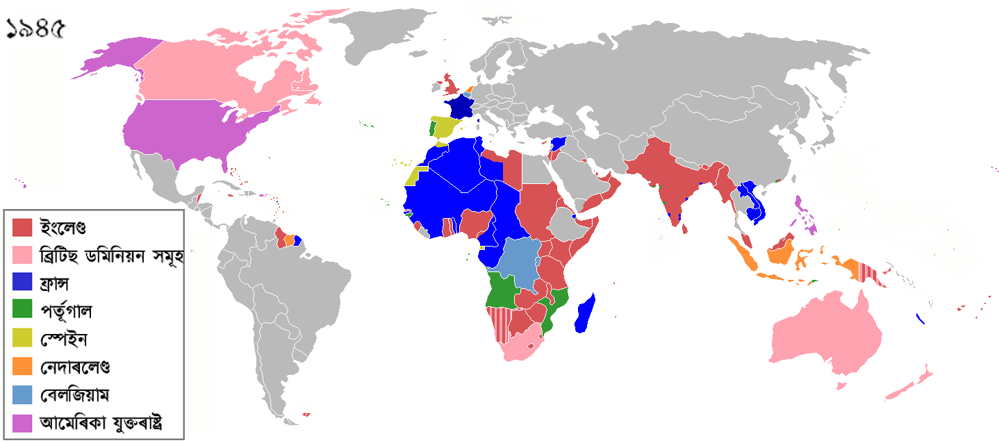
The colors represent the colonies of various nations in 1945, and the colonial borders of that time. The derived file has the names of the countries in Assamese language. English: Colonisation in 1945 Español: Colonialismo en 1945 한국어: 1945년의 국가들 |
| তাৰিখ | (UTC) |
| উৎস |
This file was derived from: Colonization 1945.png: |
| লেখক |
|
| This is a retouched picture, which means that it has been digitally altered from its original version. Modifications: changed English country names to Assamese. The original can be viewed here: Colonization 1945.png:
|
অনুজ্ঞাপত্ৰ
মই, এই কামৰ স্বত্বাধিকাৰী, ইয়াৰ দ্বাৰা মই এই কামক তলত বৰ্ননা দিয়া অনুজ্ঞাপত্ৰৰ অধীনত প্ৰকাশ কৰিলো:
এই ফাইলটো ক্ৰিয়েটিভ কমন্স এট্ৰিবইউচন-চেয়াৰ এলাইক ৩.০ আন্প'ৰ্টেড অনুজ্ঞাপত্ৰৰ অধীনত।
- আপুনি স্বাধীনভাৱে:
- বিতৰণ কৰিব পাৰে – কামটো নকল (কপি), বিতৰণ আৰু প্ৰেৰণ কৰিবলৈ
- পুনৰ্মিশ্ৰণ কৰিবলৈ – কামটো অভিযোজন কৰিবলৈ
- তলত উল্লেখ কৰা চৰ্ত্তসমূহৰ ভিত্তিত:
- স্বীকৃতিপ্ৰদান – আপুনি প্ৰয়োজনীয় স্বীকৃতি দিয়াৰ লগতে অনুজ্ঞাপত্ৰলৈ লিংক আৰু কোনো সালসলনিৰ ইংগিত দিব লাগিব। আপুনি এয়া উপযুক্ত ধৰণেৰে দিব পাৰে, মাত্ৰ অনুজ্ঞাপত্ৰধাৰীয়ে আপোনাক বা আপোনাৰ কামক মঞ্জুৰী জনোৱাৰ দৰে নিলিখিব।
- একে ধৰণে চেয়াৰ কৰক – যদি আপুনি এই কামটো পৰিবৰ্তন, ৰূপান্তৰ বা এই কামটোৰ উপৰত ভিত্তি কৰি নতুন সৃষ্টিকৰ্ম তৈয়াৰ কৰে, আপুনি শেষৰ কৰ্মটো পূৰ্বৰ কৰ্মটোৰ সৈতে একে বা একেধৰণৰ অনুজ্ঞাপত্ৰৰ আওতাত বিতৰণ কৰিব পাৰে।
মূল আপলোড ল’গ
This image is a derivative work of the following images:
- File:Colonization_1945.png licensed with Cc-by-sa-3.0
- 2012-08-26T14:08:03Z Hamodi1234 1438x638 (93790 Bytes) Fixed Brazil
- 2012-08-26T14:05:51Z Hamodi1234 1438x638 (93885 Bytes) Fixed Brazil and Syria
- 2012-07-24T14:04:22Z Soerfm 1438x638 (83090 Bytes) Legend
- 2012-06-09T09:14:44Z Ozzorro 1425x625 (46672 Bytes) Repositioned image and fixed colours to match other maps in the 'Colonisation' series (1492, 1550, 1660, 1754, 1800, 1822, 1885, 1914, 1938, 1959, 1974, 2007) - also corrected island positions. Suggestion: The 'British Domi
- 2012-06-09T09:10:31Z Ozzorro 1425x625 (46672 Bytes) Repositioned image to match other maps in the Colonisation series (1492, 1550, 1660, 1754, 1800, 1822, 1885, 1914, 1938, 1959, 1974, 2007), and also slightly modified colours and corrected island positions. The 'British Domi
- 2011-12-22T02:06:23Z Lemonade100 1356x674 (38879 Bytes) Reverted to version as of 00:46, 9 September 2011 as despite being memebers[sic] of the UN were still colonies of their respective imperial nations.
- 2011-12-03T08:47:28Z 23prootie 1356x674 (65062 Bytes) The [[:en:Philippine Commonwealth|Philippine Commonwealth]] and [[India]] were already members of the United Nations. They don't count.
- 2011-09-09T00:46:00Z SpencerCS 1356x674 (38879 Bytes) Independent Syria, corrected Cameroon, split British Somaliland from occupied Italian Somaliland.
- 2011-03-28T17:48:34Z Lemonade100 1356x674 (52448 Bytes) see below
- 2011-03-28T17:43:09Z Lemonade100 1356x674 (52448 Bytes) reverted to previous as AUS, CAN, NA and SA were considered Dominions at the time. Also, the British Parliament reatained the right to legilate on their behalf until the 1980s for AUS CAN and NZ; in 1960s for South Africa whe
- 2010-12-10T01:59:19Z Maps & Lucy 1357x628 (35364 Bytes) Reverted to version as of 12:09, 7 July 2008 Canada (excluding Newfoundland), Australia, New Zealand and South Africa had become Commonwealth Realms in 1931 therefore no longer being part of the British Empire!
- 2010-05-12T18:56:47Z Lemonade100 1356x674 (52448 Bytes) Added the British dominions (not yet independant) and their colonies.
- 2009-11-08T03:28:48Z Shipguy 1357x628 (23062 Bytes) {{Information |Description=== |Source=*[[:File:Colonization_1945.png|]] |Date=2009-11-08 03:26 (UTC) |Author=*[[:File:Colonization_1945.png|]]: Shipguy *derivative work: ~~~ |Permission=see below |other_versions= }} {{Retouc
- 2008-07-07T12:09:08Z Samulili 1357x628 (35364 Bytes) reverted to an earlier larger version
- 2008-05-21T04:03:09Z Pruxo 800x370 (75151 Bytes) {{Information |Description=aumento del contraste, anteriormente no se distinguían los continentes |Source=self-made |Date= |Author= [[User:Pruxo|Pruxo]] |Permission= |other_versions= }}
- 2006-12-22T06:02:16Z Roke 1357x628 (35364 Bytes) Reverted to earlier revision
- 2006-12-01T01:27:30Z Deltabeignet 1357x628 (50283 Bytes) Removed Newfoundland as per user request
- 2006-06-28T13:43:47Z Roke 1357x628 (35364 Bytes) remove italy and japan - defeated powers should not be shown in a 1945 map of colonialism
- 2006-05-13T22:03:47Z Yom 1357x628 (53540 Bytes) == Summary == '''Description''': Updated by [[en:User:Yom]] to correct the file created by [[en:User:Aris Katsaris]] (which was created to replace and partially correct the smaller[[:en:Image:800px_colonization_1945.png]] whi
- 2006-02-22T21:32:09Z Zinn 1357x628 (53390 Bytes) == Summary == '''Description''': Created by [[en:User:Aris Katsaris]] to replace and partially correct the smaller[[:en:Image:800px_colonization_1945.png]] which was in turn based on the different-languaged and improperly ext
- 2005-10-01T20:04:00Z Nuno Tavares 1357x628 (53479 Bytes) '''Description''': Created by [[en:User:Aris Katsaris]] to replace and partially correct the smaller[[:en:Image:800px_colonization_1945.png]] which was in turn based on the different-languaged and improperly extensioned [[:en
Uploaded with derivativeFX
ফাইলৰ ইতিবৃত্ত
ফাইলৰ আগৰ অৱস্থা চাবলৈ সেই তাৰিখ/সময়ত ক্লিক কৰক।
| তাৰিখ/সময় | ক্ষুদ্ৰ প্ৰতিকৃতি | আকাৰ | সদস্য | মন্তব্য | |
|---|---|---|---|---|---|
| বৰ্তমান | 22:08, 20 July 2018 | | 1,438 × 638 (3.51 MB) | SuperSucker | UK |
| 20:25, 10 September 2012 |  | 1,438 × 638 (90 KB) | উদ্দীপতালুকদাৰ | == {{int:filedesc}} == {{Information |Description=The colors represent the colonies of various nations in 1945, and the colonial borders of that time. The derived file has the names of the countries in Assamese language. {{en|Colonisation in 1945}} {{e... |
ফাইল ব্যৱহাৰ
তলত দিয়া পৃষ্ঠাটোৱে এই ফাইলটো ব্যৱহাৰ কৰে: