
চিত্ৰ:Windmills D1-D4 - Thornton Bank.jpg
এই খচৰাৰ আকাৰ: 379 × 600 পিক্সেল. আন ৰিজ'লিউশ্যনসমূহ: 151 × 240 পিক্সেল | 303 × 480 পিক্সেল | 485 × 768 পিক্সেল | 647 × 1,024 পিক্সেল | 2,421 × 3,831 পিক্সেল।
মূল ফাইল (2,421 × 3,831 পিক্সেল, ফাইলৰ মাত্ৰা: 2.53 MB, MIME প্ৰকাৰ: image/jpeg)
| এই ফাইলটো ৱিকিমিডিয়া কমন্সৰ পৰা আমদানি কৰা হৈছে। ফাইল বিৱৰণ পৃষ্ঠাৰ সবিশেষ তথ্য তলত উল্লেখ কৰা হ’ল ।
|
| Camera location | | View this and other nearby images on: OpenStreetMap |
|---|
| Photographer |
Hans Hillewaert |
| বিৱৰণ |
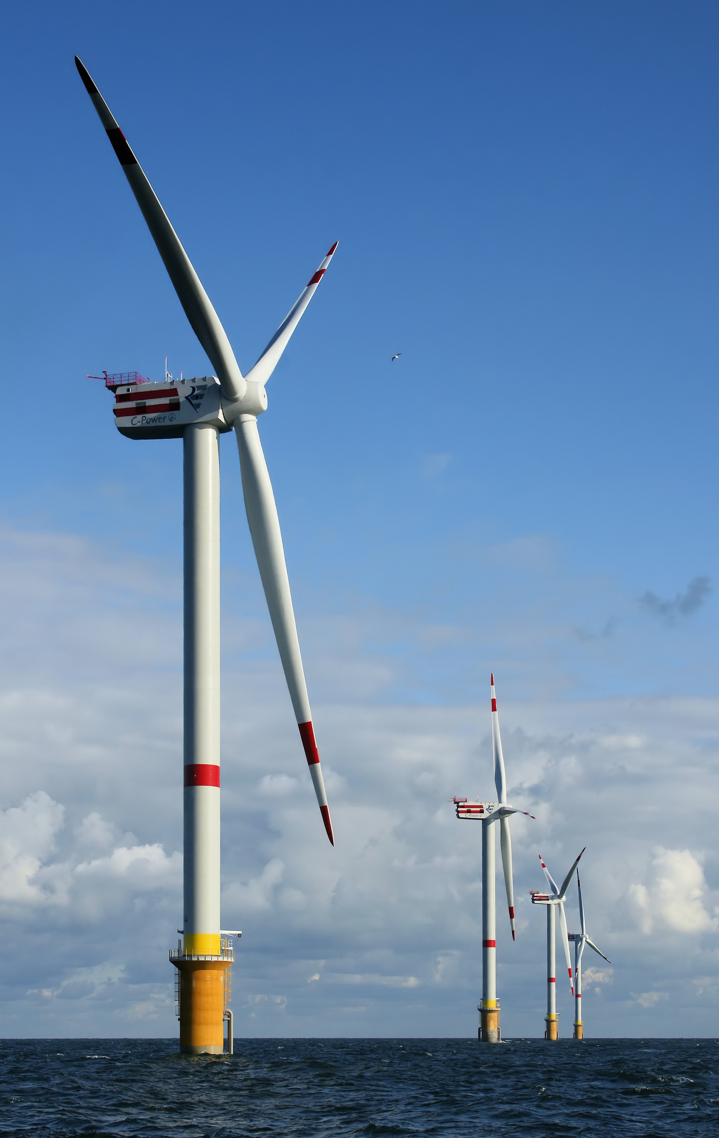
English: Newly constructed windmills D4 (nearest) to D1 on the Thornton Bank, 28 km off shore, on the Belgian part of the North Sea.
The windmills are 157m (+TAW) high, 184m above the sea bottom.
Français : Les éoliennes D1 à D4 nouvellement construites sur le banc de Thorton, à 28 km des côtes, sur le plateau continental belge. Ces éoliennes font 61 mètres de rayon, et sont portées par des tours de 157m de haut. Elles alimentent des turbines de 5 MW produites par la compagnie REpower. |
| তাৰিখ | ২৯ ছেপ্টেম্বৰ ২০০৮ |
| উৎস | নিজা কাৰ্য |
| অনুমতি (এই ফাইলৰ পুনঃব্যৱহাৰ) |
This file is licensed under the Creative Commons Attribution-Share Alike 4.0 International license. স্বীকৃতিপ্ৰদান: © Hans Hillewaert
|
| Other licenses | More (4100+) and new images on : High resolution files on request. . |
| স্বীকৃতিপ্ৰদান (required by the license) | © Hans Hillewaert / |
This image has been assessed using the Quality image guidelines and is considered a Quality image.
|

|
This image has been assessed under the valued image criteria and is considered the most valued image on Commons within the scope: Offshore wind park. You can see its nomination here. |
ফাইলৰ ইতিবৃত্ত
ফাইলৰ আগৰ অৱস্থা চাবলৈ সেই তাৰিখ/সময়ত ক্লিক কৰক।
| তাৰিখ/সময় | ক্ষুদ্ৰ প্ৰতিকৃতি | আকাৰ | সদস্য | মন্তব্য | |
|---|---|---|---|---|---|
| বৰ্তমান | 13:40, 13 October 2008 | | 2,421 × 3,831 (2.53 MB) | Lycaon | {{location dec|51.54550|2.92985}} {{Information |Description={{en|Newly constructed windmills D4 (nearest) to D1 on the Thornton Bank, 28 km off shore, on the Belgian part of the North Sea.<br> The windmills are 157m (+TAW) high, 184m above the sea botto |
ফাইল ব্যৱহাৰ
তলত দিয়া পৃষ্ঠাটোৱে এই ফাইলটো ব্যৱহাৰ কৰে:
ফাইলৰ গোলকীয় ব্যৱহাৰ
তলত দিয়া আন ৱিকিসমূহে এই ফাইলটো ব্যৱহাৰ কৰে:
- af.wikipedia.org-ৰ ব্যৱহাৰ
- ar.wikipedia.org-ৰ ব্যৱহাৰ
- تنمية مستدامة
- طاقة متجددة
- وقود حيوي
- تنقية المياه
- تدوير النفايات
- تحديد النسل
- طاقة بديلة
- هندسة الطاقة
- تقييم الأثر البيئي
- بناء مستدام
- مركبة هجينة
- بوابة:هندسة/صورة مختارة/أرشيف
- إدارة المخلفات
- تجارة الطاقة المتجددة
- استخدام فعال للطاقة
- مركبة كهربائية
- معالجة الصرف الصحي
- مبنى طبيعي
- تقانة بيئية
- بيئوية
- عمارة مستدامة
- نقل مستدام
- زراعة معمرة
- قالب:تقنية بيئية
- موارد متجددة
- بوابة:تنمية مستدامة
- بوابة:تنمية مستدامة/مواضيع
- حوسبة خضراء
- بوابة:هندسة/صورة مختارة/12
- تقانات الهيدروجين
- تقنية نظيفة
- تمويل الكربون
- حافلة كهربائية هجينة
- وقود بديل
- طاقة مستدامة
- تنمية الطاقة
- وقود محايد للكربون
- بارك أند تشارج
- لا جاميس كونتي
- مرحاض سمادي
- معالجة المخلفات الصناعية السائلة
- تكنولوجيا المعلومات الخضراء
- تصميم بيئي
- معالجة مياه الصرف الزراعية
- إصلاح بيئي
- استرجاع الطاقة
- مستخدم:ASEN6/ملعب17
- مستخدم:ASEN6/ملعب54
- مستخدم:ASEN6/ملعب70
এই ফাইলটোৰ অধিক গোলকীয় ব্যৱহাৰ চাওক।