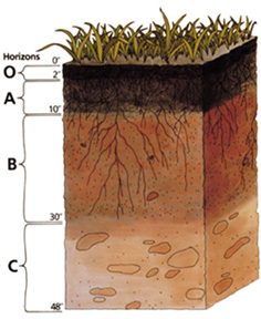
চিত্ৰ:Soil profile.jpg
Soil_profile.jpg (236 × 288 পিক্সেল, ফাইলৰ মাত্ৰা: 39 KB, MIME প্ৰকাৰ: image/jpeg)
ফাইলৰ ইতিবৃত্ত
ফাইলৰ আগৰ অৱস্থা চাবলৈ সেই তাৰিখ/সময়ত ক্লিক কৰক।
| তাৰিখ/সময় | ক্ষুদ্ৰ প্ৰতিকৃতি | আকাৰ | সদস্য | মন্তব্য | |
|---|---|---|---|---|---|
| বৰ্তমান | 00:35, 24 November 2004 |  | 236 × 288 (39 KB) | Paleorthid | Soil profile 236x288 38.76 KB {{PD-USGov-USDA}} |
ফাইল ব্যৱহাৰ
ফাইলৰ গোলকীয় ব্যৱহাৰ
তলত দিয়া আন ৱিকিসমূহে এই ফাইলটো ব্যৱহাৰ কৰে:
- af.wikipedia.org-ৰ ব্যৱহাৰ
- ar.wikipedia.org-ৰ ব্যৱহাৰ
- ast.wikipedia.org-ৰ ব্যৱহাৰ
- az.wikipedia.org-ৰ ব্যৱহাৰ
- be-tarask.wikipedia.org-ৰ ব্যৱহাৰ
- be.wikipedia.org-ৰ ব্যৱহাৰ
- bh.wikipedia.org-ৰ ব্যৱহাৰ
- bjn.wikipedia.org-ৰ ব্যৱহাৰ
- bn.wikipedia.org-ৰ ব্যৱহাৰ
- ca.wikipedia.org-ৰ ব্যৱহাৰ
- cs.wikipedia.org-ৰ ব্যৱহাৰ
- cy.wikipedia.org-ৰ ব্যৱহাৰ
- da.wikipedia.org-ৰ ব্যৱহাৰ
- de.wikipedia.org-ৰ ব্যৱহাৰ
- Podsol
- Boden (Bodenkunde)
- Solonetz
- USDA Soil Taxonomy
- Inceptisol
- Entisol
- Andisol
- Gelisol
- Alfisol
- Oxisol
- Histosol
- Spodosol
- Ultisol
- Aridisol
- Vertisol
- Mollisol
- Portal:Geowissenschaften
- Portal:Geowissenschaften/Disziplinen
- Benutzer:BK-Thorsten/Entwurf
- Benutzer:BK-Thorsten
- Acrisol
- Ferralsol
- Nitisol
- Cryosol
- Benutzer:Flaovia/Humus
- Lixisol
- Andosol
এই ফাইলটোৰ অধিক গোলকীয় ব্যৱহাৰ চাওক।


