
চিত্ৰ:Badami-chalukya-empire-map.svg

মূল ফাইল (SVG ফাইল, সাধাৰণতঃ 1,510 × 1,753 পিক্সেল, ফাইল মাত্ৰা: 339 KB)
| এই ফাইলটো ৱিকিমিডিয়া কমন্সৰ পৰা আমদানি কৰা হৈছে। ফাইল বিৱৰণ পৃষ্ঠাৰ সবিশেষ তথ্য তলত উল্লেখ কৰা হ’ল ।
|
সাৰাংশ
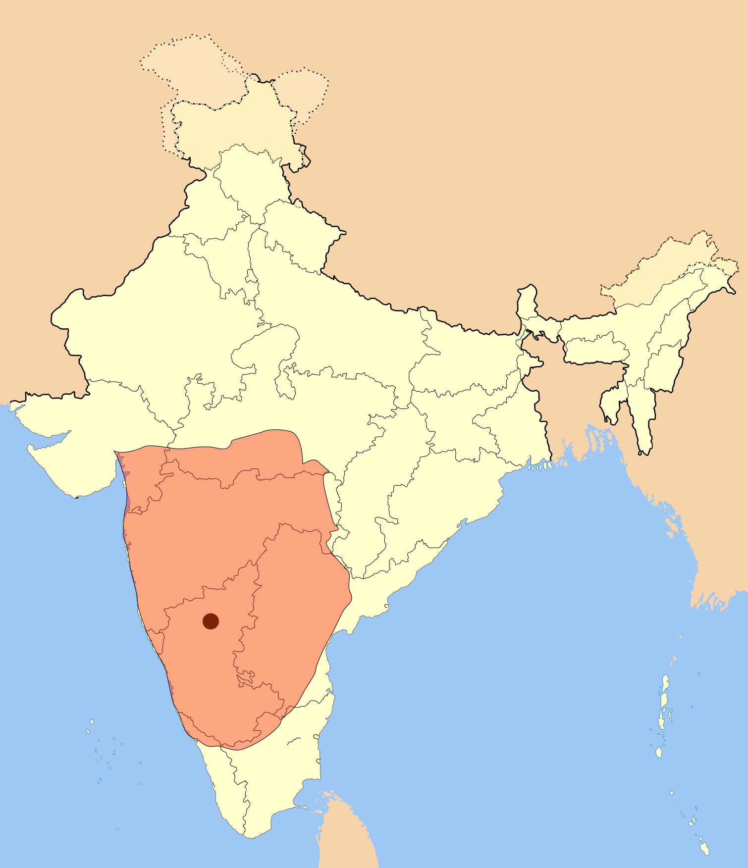
I used Image:India-locator-map-blank.svg as base and edited myself using inkspace and created it by looking at the following source.
Suryanath U. Kamat, A Concise history of Karnataka from pre-historic times to the present, Jupiter books, MCC, Bangalore, 2001 (Reprinted 2002) OCLC: 7796041 p327
A province of this empire comprising of Andhra region became the "Eastern Chalukyas" in the years following the death of Pulakesi II.
Note: Original source has overlay of Kadamba, Rastrakuta and Western Ganga kingdom maps on the same page, I placed only the Badami Chalukya empire map.
| বিৱৰণ | Badami Chalukya Empire Map |
| তাৰিখ | |
| উৎস | নিজা কাৰ্য |
| লেখক | Mlpkr |
অনুজ্ঞাপত্ৰ

|
GNU Free Documentation License ৰ চুক্তিসমূহৰ অন্তৰ্গত এই দস্তাবেজ কপি, বিতৰণ আৰু/অথবা সলনি কৰাৰ অনুমতি প্ৰদান কৰা হৈছে, সংস্কৰণ 1.2 অথবা Free Software Foundation দ্বাৰা প্ৰকাশ কৰা পিছৰ যিকোনো সংস্কৰণত; কোনো অপৰিবৰ্তনশীল অংশ, কোনো ফ্ৰন্ট-কভাৰ টেক্সট, আৰু কোনো বেক-কভাৰ টেক্সট নহোৱাকৈ। অনুজ্ঞাৰ এটা কপি GNU Free Documentation License নামৰ অংশত অন্তৰ্ভুক্ত কৰা হৈছে। |
| এই ফাইলটো ক্ৰিয়েটিভ কমন্স এট্ৰিবইউচন-চেয়াৰ এলাইক ৩.০ আন্প'ৰ্টেড অনুজ্ঞাপত্ৰৰ অধীনত। | ||
| ||
| এই অনুজ্ঞা টেগ এই ফাইলত GFDL অনুজ্ঞা আপডেইট ৰ অংশ হিচাপে যোগ কৰা হৈছিল। |
- আপুনি স্বাধীনভাৱে:
- বিতৰণ কৰিব পাৰে – কামটো নকল (কপি), বিতৰণ আৰু প্ৰেৰণ কৰিবলৈ
- পুনৰ্মিশ্ৰণ কৰিবলৈ – কামটো অভিযোজন কৰিবলৈ
- তলত উল্লেখ কৰা চৰ্ত্তসমূহৰ ভিত্তিত:
- স্বীকৃতিপ্ৰদান – আপুনি প্ৰয়োজনীয় স্বীকৃতি দিয়াৰ লগতে অনুজ্ঞাপত্ৰলৈ লিংক আৰু কোনো সালসলনিৰ ইংগিত দিব লাগিব। আপুনি এয়া উপযুক্ত ধৰণেৰে দিব পাৰে, মাত্ৰ অনুজ্ঞাপত্ৰধাৰীয়ে আপোনাক বা আপোনাৰ কামক মঞ্জুৰী জনোৱাৰ দৰে নিলিখিব।
- একে ধৰণে চেয়াৰ কৰক – যদি আপুনি এই কামটো পৰিবৰ্তন, ৰূপান্তৰ বা এই কামটোৰ উপৰত ভিত্তি কৰি নতুন সৃষ্টিকৰ্ম তৈয়াৰ কৰে, আপুনি শেষৰ কৰ্মটো পূৰ্বৰ কৰ্মটোৰ সৈতে একে বা একেধৰণৰ অনুজ্ঞাপত্ৰৰ আওতাত বিতৰণ কৰিব পাৰে।
ফাইলৰ ইতিবৃত্ত
ফাইলৰ আগৰ অৱস্থা চাবলৈ সেই তাৰিখ/সময়ত ক্লিক কৰক।
| তাৰিখ/সময় | ক্ষুদ্ৰ প্ৰতিকৃতি | আকাৰ | সদস্য | মন্তব্য | |
|---|---|---|---|---|---|
| বৰ্তমান | 00:28, 19 July 2017 | | 1,510 × 1,753 (339 KB) | Renato de Carvalho Ferreira | Ajustes gerais |
| 22:49, 27 May 2007 |  | 1,651 × 1,753 (432 KB) | Mlpkr | I used Image:India-locator-map-blank.svg as base and edited myself using inkspace and created it by looking at the following source. Suryanath U. Kamat, A Concise history of Karnataka from pre-historic times to the present, Jupiter books, MCC, Bangalore | |
| 23:09, 26 May 2007 |  | 1,651 × 1,753 (432 KB) | Mlpkr | == Summary == I used Image:India-locator-map-blank.svg as base and edited myself using inkspace and created it by looking at the following source. Suryanath U. Kamat, A Concise history of Karnataka from pre-historic times to the present, Jupiter books, | |
| 22:25, 26 May 2007 |  | 1,651 × 1,753 (431 KB) | Mlpkr | {{Information |Description= |Source=self-made |Date= |Author= User:Mlpkr }} |
ফাইল ব্যৱহাৰ
এই ফাইলটো কোনো পৃষ্ঠাই ব্যৱহাৰ কৰা নাই
ফাইলৰ গোলকীয় ব্যৱহাৰ
তলত দিয়া আন ৱিকিসমূহে এই ফাইলটো ব্যৱহাৰ কৰে:
- ar.wikipedia.org-ৰ ব্যৱহাৰ
- ba.wikipedia.org-ৰ ব্যৱহাৰ
- bn.wikipedia.org-ৰ ব্যৱহাৰ
- ca.wikipedia.org-ৰ ব্যৱহাৰ
- da.wikipedia.org-ৰ ব্যৱহাৰ
- en.wikipedia.org-ৰ ব্যৱহাৰ
- es.wikipedia.org-ৰ ব্যৱহাৰ
- fi.wikipedia.org-ৰ ব্যৱহাৰ
- fr.wikipedia.org-ৰ ব্যৱহাৰ
- gu.wikipedia.org-ৰ ব্যৱহাৰ
- hi.wikipedia.org-ৰ ব্যৱহাৰ
- hu.wikipedia.org-ৰ ব্যৱহাৰ
- hy.wikipedia.org-ৰ ব্যৱহাৰ
- id.wikipedia.org-ৰ ব্যৱহাৰ
- it.wikipedia.org-ৰ ব্যৱহাৰ
- ja.wikipedia.org-ৰ ব্যৱহাৰ
- ka.wikipedia.org-ৰ ব্যৱহাৰ
- kn.wikipedia.org-ৰ ব্যৱহাৰ
- ko.wikipedia.org-ৰ ব্যৱহাৰ
- lt.wikipedia.org-ৰ ব্যৱহাৰ
- ml.wikipedia.org-ৰ ব্যৱহাৰ
- mr.wikipedia.org-ৰ ব্যৱহাৰ
- ms.wikipedia.org-ৰ ব্যৱহাৰ
- ne.wikipedia.org-ৰ ব্যৱহাৰ
এই ফাইলটোৰ অধিক গোলকীয় ব্যৱহাৰ চাওক।