
চিত্ৰ:Hindutagh-pass-aksai-chin-center2-1873.jpg

এই খচৰাৰ আকাৰ: 420 × 600 পিক্সেল. আন ৰিজ'লিউশ্যনসমূহ: 168 × 240 পিক্সেল | 336 × 480 পিক্সেল | 537 × 768 পিক্সেল | 717 × 1,024 পিক্সেল | 1,386 × 1,980 পিক্সেল।
মূল ফাইল (1,386 × 1,980 পিক্সেল, ফাইলৰ মাত্ৰা: 409 KB, MIME প্ৰকাৰ: image/jpeg)
| এই ফাইলটো ৱিকিমিডিয়া কমন্সৰ পৰা আমদানি কৰা হৈছে। ফাইল বিৱৰণ পৃষ্ঠাৰ সবিশেষ তথ্য তলত উল্লেখ কৰা হ’ল ।
|
সাৰাংশ
| বিৱৰণ |
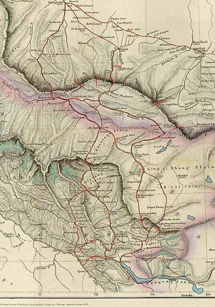
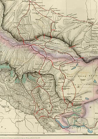
English: Image of map of the Baltistan, Aksai Chin, Chinese Turkestan in maps of Central Asia. The international border between the British Indian Empire (including the Kashmir region) and Chinese Turkestan is shown two-toned purple and pink. From the article, "On the Geographical Results of the Mission to Kashghar, under Sir T. Douglas Forsyth in 1873-74" by H. Trotter
Journal of the Royal Geographical Society of London, Vol. 48. (1878), pp. 173-234. Downloaded, resized to 33% of original size and annotated by Fowler&fowler«Talk» 23:52, 8 July 2007 (UTC) |
| উৎস | Article= "On the Geographical Results of the Mission to Kashghar, under Sir T. Douglas Forsyth in 1873-74" by H. Trotter, Journal of the Royal Geographical Society of London, Vol. 48. (1878), pp. 173-234. |
| লেখক | H. Trotter |
| অন্যান্য সংস্কৰণ |
.jpg)

অনুজ্ঞাপত্ৰ
|
This is a faithful photographic reproduction of a two-dimensional, public domain work of art. The work of art itself is in the public domain for the following reason:
The official position taken by the Wikimedia Foundation is that "faithful reproductions of two-dimensional public domain works of art are public domain".
This photographic reproduction is therefore also considered to be in the public domain in the United States. In other jurisdictions, re-use of this content may be restricted; see Reuse of PD-Art photographs for details. | ||||
মূল আপলোড ল’গ
The original description page was here. All following user names refer to en.wikipedia.
- 2007-07-08 23:50 Fowler&fowler 1386×1980× (419033 bytes) Image of map of Central Asia from the article, [http://www.jstor.org/stable/1798763 "On the Geographical Results of the Mission to Kashghar, under Sir T. Douglas Forsyth in 1873-74"] by H. Trotter ''Journ
| Annotations | This image is annotated: View the annotations at Commons |
ফাইলৰ ইতিবৃত্ত
ফাইলৰ আগৰ অৱস্থা চাবলৈ সেই তাৰিখ/সময়ত ক্লিক কৰক।
| তাৰিখ/সময় | ক্ষুদ্ৰ প্ৰতিকৃতি | আকাৰ | সদস্য | মন্তব্য | |
|---|---|---|---|---|---|
| বৰ্তমান | 21:49, 19 January 2010 | | 1,386 × 1,980 (409 KB) | File Upload Bot (Magnus Manske) | {{BotMoveToCommons|en.wikipedia|year={{subst:CURRENTYEAR}}|month={{subst:CURRENTMONTHNAME}}|day={{subst:CURRENTDAY}}}} {{Information |Description={{en|Image of map of the Baltistan, Aksai Chin, Chinese Turkestan in maps of Central Asia. The internationa |
ফাইল ব্যৱহাৰ
তলত দিয়া পৃষ্ঠাটোৱে এই ফাইলটো ব্যৱহাৰ কৰে:
ফাইলৰ গোলকীয় ব্যৱহাৰ
তলত দিয়া আন ৱিকিসমূহে এই ফাইলটো ব্যৱহাৰ কৰে:
- en.wikipedia.org-ৰ ব্যৱহাৰ
- es.wikipedia.org-ৰ ব্যৱহাৰ
- fr.wikipedia.org-ৰ ব্যৱহাৰ
- hi.wikipedia.org-ৰ ব্যৱহাৰ
- it.wikipedia.org-ৰ ব্যৱহাৰ
- no.wikipedia.org-ৰ ব্যৱহাৰ
- or.wikipedia.org-ৰ ব্যৱহাৰ
- pnb.wikipedia.org-ৰ ব্যৱহাৰ
- ru.wikipedia.org-ৰ ব্যৱহাৰ
- sh.wikipedia.org-ৰ ব্যৱহাৰ
- sl.wikipedia.org-ৰ ব্যৱহাৰ
- te.wikipedia.org-ৰ ব্যৱহাৰ
- uz.wikipedia.org-ৰ ব্যৱহাৰ
- vi.wikipedia.org-ৰ ব্যৱহাৰ
- www.wikidata.org-ৰ ব্যৱহাৰ
- zh.wikipedia.org-ৰ ব্যৱহাৰ