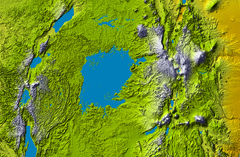
ভিক্টোৰিয়া হ্ৰদ
| Nalubaale (ভিক্টোৰিয়া হ্ৰদ) | |
|---|---|

| |
| অৱস্থান | African Great Lakes |
| স্থানাংক | 1°S 33°E / 1°S 33°Eস্থানাংক: 1°S 33°E / 1°S 33°E |
| Primary inflows | Kagera River |
| Primary outflows | White Nile (river) (known as the "Victoria Nile" as it flows out of the lake) |
| Catchment area | 1,84,000 বৰ্গ কি.মি. (71,000 বৰ্গ মাইল) 2,38,900 বৰ্গ কি.মি. (92,200 বৰ্গ মাইল) basin |
| Basin countries | Tanzania Uganda Kenya |
| Max. length | 337 km (209 মাইল) |
| Max. width | 250 km (160 মাইল) |
| Surface area | 68,800 বৰ্গ কি.মি. (26,600 বৰ্গ মাইল) |
| Average depth | 40 মিটাৰ (130 ফুট) |
| Max. depth | 83 মিটাৰ (272 ফুট) |
| Water volume | সাঁচ:Convert/km3 |
| Shore length1 | 3,440 km (2,140 মাইল) |
| Surface elevation | 1,133 মিটাৰ (3,717 ফুট) |
| Islands | 84 (Ssese Islands, Uganda; Maboko Island, Kenya) |
| Settlements | Bukoba, Tanzania Mwanza, Tanzania Musoma, Tanzania Kisumu, Kenya Kendu Bay, Kenya Homa Bay, Kenya Kampala, Uganda Entebbe, Uganda Jinja, Uganda |
| 1 Shore length is not a well-defined measure. | |

ভিক্টোৰিয়া হ্ৰদ (Nam Lolwe in Luo; "Nalubaale" in Luganda; Nyanza in Kinyarwanda and some Bantu languages[1]) আফ্ৰিকাৰ বৃহৎ হ্ৰদসমূহ (African Great Lakes) ৰ ভিতৰত এক উল্লেখযোগ্য হ্ৰদ৷ এই হ্ৰদৰ বিষয়ে তথ্য সংগ্ৰহ কৰা প্ৰথম ইংৰাজ পৰিব্ৰাজক জ’ন হেনিং স্পেক ( John Hanning Speke) -এ ৰাণী ভিক্টোৰিয়াৰ নামেৰে ইয়াৰ নাম ভিক্টোৰিয়া হ্ৰদ ৰাখে৷ স্পেকে ১৮৫৮ চনত নীলনদীৰ উৎসৰ অনুসন্ধানত আৰম্ভ কৰা এক অভিযানত এই হ্ৰদ আৱিস্কাৰ কৰে ৷[2][3]
ভৌগোলিক বিৱৰণ
[সম্পাদনা কৰক]ভিক্টোৰিয়া হ্ৰদৰ কালি (surface area) ৬৮,৮০০ বৰ্গ কি.মি. (26,600 বৰ্গ মাইল)৷ ই আফ্ৰিকাৰ লগতে ক্ৰান্তীয় বিশ্বৰ সৰ্ববৃহৎ হ্ৰদ ৰূপে স্বীকৃতপ্ৰাপ্ত৷ উত্তৰ আমেৰিকাৰ ছুপিৰিঅ’ৰ হ্ৰদ (Lake Superior) ৰ পিছতে এই হ্ৰদ পৃথিৱীৰ ভিতৰতে সৰ্ববৃহৎ হ্ৰদ ৷ আয়তনৰ ফালৰ পৰা ভিক্টোৰিয়া হ্ৰদ পৃথিৱীৰ ভিতৰতে নৱম সৰ্ববৃহৎ মহাদেশীয় হ্ৰদ (largest continental lake) আৰু ই প্ৰায় ২,৭৫০ কিউবিক কিলোমিটাৰ পানী ধৰি ৰাখিছে ৷
ভিক্টোৰিয়া হ্ৰদৰ পানীৰ মূল উৎস পোনপটীয়া precipitation সহস্ৰাধিক সৰু-বৰ জুৰি ৷ এইবোৰৰ ভিতৰত হ্ৰদলৈ প্ৰবাহিত হোৱা সৰ্ববৃহৎ নৈখন হ’ল কাগেৰা নদী (Kagera River) ৷ [4]
এই হ্ৰদৰ আফ্ৰিকাত গভীৰতা কম ৷ গড় গভীৰতা 40 মিটাৰ (130 ফুট) আৰু আটাইতকৈ গভীৰ অঞ্চলত ই 84 মিটাৰ (276 ফুট) গভীৰ ৷[5] ভিক্টোৰিয়া হ্ৰদৰ অৱবাহিকা (catchment area) ৰ কালি প্ৰায় ১৮৪,০০০ বৰ্গ কিলোমিটাৰ ৷ এই হ্ৰদৰ পাৰ প্ৰায় 4,828 km (3,000 মাইল) জুৰি বিস্তৃত হৈ আছে ৷[6] ভিক্টোৰিয়া হ্ৰদ তিনিখন দেশ জুৰি বিস্তৃত - কেনিয়া (৬% বা সাঁচ:Convert/LoffAonDorSoff), উগাণ্ডা (৪৫% বা সাঁচ:Convert/LoffAonDorSoff) আৰু টানজানিয়া (৪৯% বা সাঁচ:Convert/LoffAonDorSoff).[7]
তথ্যসূত্ৰ
[সম্পাদনা কৰক]- ↑ "The Victoria Nyanza. The Land, the Races and their Customs, with Specimens of Some of the Dialects". World Digital Library. http://www.wdl.org/en/item/2557। আহৰণ কৰা হৈছে: 18 February 2013.
- ↑ Dalya Alberge (11 September 2011). "How feud wrecked the reputation of explorer who discovered Nile's source". The Observer (The Guardian). http://www.theguardian.com/books/2011/sep/11/burton-speke-african-exploration-nile। আহৰণ কৰা হৈছে: 29 December 2013.
- ↑ Moorehead, Alan (1960). "Part One: Chapters 1-7". The White Nile. Harper & Row. ISBN 0-06-095639-9.
- ↑ vanden Bossche, J.-P.; Bernacsek, G. M. (1990). Source Book for the Inland Fishery Resources of Africa, Issue 18, Volume 1. Food & Agriculture Org. (United Nations). পৃষ্ঠা. 291. ISBN 92-5-102983-0. http://books.google.co.uk/books?id=WLZRxM9vfXoC। আহৰণ কৰা হৈছে: 29 December 2013.
- ↑ United Nations, Development and Harmonisation of Environmental Laws Volume 1: Report on the Legal and Instituional Issues in the Lake Victoria Basin, United Nations, 1999, page 17
- ↑ C. F. Hickling (1961). Tropical Inland Fisheries. প্ৰকাশক London: Longmans.
- ↑ J. Prado, R. J. Beare, J. Siwo Mbuga & L. E. Oluka, 1991. A catalogue of fishing methods and gear used in Lake Victoria. UNDP/FAO Regional Project for Inland Fisheries Development (IFIP), FAO RAF/87/099-TD/19/91 (En). Rome, Food and Agricultural Organisation.
বাহ্যিক সংযোগ
[সম্পাদনা কৰক]| ৱিকিমিডিয়া কমন্সত Lake Victoria সম্পৰ্কীয় মিডিয়া ফাইল আছে। |
- Decreasing levels of Lake Victoria Worry East African Countries
- Bibliography on Water Resources and International Law Peace Palace Library
- New Scientist article on Uganda's violation of the agreed curve for hydroelectric water flow.
- Dams Draining Lake Victoria Archived 2012-03-10 at the Wayback Machine
- Troubled Waters: The Coming Calamity on Lake Victoria Archived 2013-05-23 at the Wayback Machine multimedia from CLPMag.org
- Specie List of Lake Victoria Basin Archived 2015-09-23 at the Wayback Machine Cichlids of Lake Victoria and surrounding lakes
- G. D. Hale Carpenter joined the London School of Hygiene and Tropical Medicine, and took the DM in 1913 with a dissertation on the tsetse fly (Glossina palpalis) and African trypanosomiasis (sleeping sickness). He published: A Naturalist on Lake Victoria, with an Account of Sleeping Sickness and the Tse-tse Fly (1920). T. F. Unwin Ltd, London; Biodiversity Archive
- http://www.youtube.com/watch?v=v9VJ6cezlnU - A beautiful video of Lake Victoria
