উত্তৰ সাগৰ
| উত্তৰ সাগৰ | |
|---|---|
 | |
| স্থান | আটলাণ্টিক মহাসাগৰ |
| স্থানাংক | 56°N 3°E / 56°N 03°Eস্থানাংক: 56°N 3°E / 56°N 03°E |
| প্ৰকাৰ | সাগৰ |
| Primary inflows | বাল্টিক সাগৰ, Elbe, Weser, Ems, Rhine/Waal, Meuse, Scheldt, Spey, Don, Dee, Tay, Forth, Tyne, Tees, Humber, Thames |
| অৱবাহিকা দেশ | নৰৱে, ডেনমাৰ্ক, জাৰ্মানী, নেডাৰলেণ্ডছ, বেলজিয়াম, ফ্ৰান্স আৰু যুক্তৰাজ্য |
| সৰ্বোচ্চ দৈৰ্ঘ্য | ৯৭০ কিমি |
| সৰ্বোচ্চ প্ৰস্থ | ৫৮০ কিমি |
| কালি | 5,70,000 বৰ্গ কি.মি. (2,20,000 বৰ্গ মাইল) |
| গড় গভীৰতা | 95 মিটাৰ (312 ফুট) |
| সৰ্বোচ্চ গভীৰতা | 700 মিটাৰ (2,300 ফুট) |
| Water volume | সাঁচ:Convert/km3 |
| Salinity | 3.4 to 3.5% |
| References | Safety at Sea and Royal Belgian Institute of Natural Sciences |
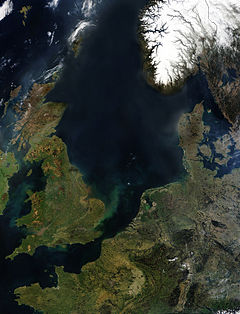
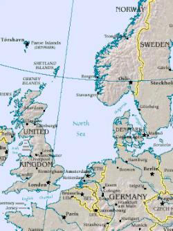
উত্তৰ সাগৰ আটলাণ্টিক মহাসাগৰৰ এক সীমামূৰীয়া সাগৰ। ই গ্ৰেট ব্ৰিটেইন, স্কেণ্ডিনাভিয়া (Scandinavia), জাৰ্মানী (Germany), নেডাৰলেণ্ড (Netherlands), বেলজিয়াম (Belgium), আৰু ফ্ৰান্সৰ মাজত অৱস্থিত। এই সাগৰে দক্ষিণে ইংলিছ চেনেল আৰু উত্তৰে নৰৱেৰিয়ান সাগৰেৰে মূল সাগৰত মিলিত হৈছে। এই সাগৰৰ দৈৰ্ঘ্য ৯৭০ কিমি. আৰু প্ৰস্থ ৫৮০ কিমি., মুঠ কালি ৫৭০,০০০বৰ্গ কিমি.।
ইউৰোপৰ জলপৰিবহণ তথা মৎস্য উদ্যোগত উত্তৰ সাগৰৰ ভূমিকা গুৰুত্বপূৰ্ণ। তদুপৰি পৰ্য্যটনৰ দিশৰ পৰাও ইয়াৰ গুৰুত্ব যথেষ্ট।
ঐতিহাসিকভাৱে, উত্তৰ সাগৰ ভাইকিং সামাজ্য উত্থানৰ কেন্দ্ৰ আছিল। পৰৱৰ্তীকালত হেনছিয়েটিক লীগ (Hanseatic League), নেডাৰলেণ্ড (Netherlands) আৰু ব্ৰিটিছে উত্তৰ সাগৰৰ ওপৰত নিজা আধিপত্য প্ৰতিষ্ঠা কৰিবলৈ চেষ্টা কৰিছিল। জাৰ্মানীৰ বাবে সাগৰলৈ একমাত্ৰ পথ হিচাপে উত্তৰ সাগৰে দুয়োখন বিশ্বযুদ্ধতে উল্লেখযোগ্য ভূমিকা পালন কৰিছিল।
উত্তৰ সাগৰৰ গতিপথত ভিন্নধৰণৰ ভৌগোলিক গঠন আৰু বৈশিষ্ট্য পোৱা যায়। উত্তৰে ন’ৰৱে আৰু স্কটিছ সাগৰীয় পাৰ থিয় শিলাময় (sheer cliffs mark) হোৱাৰ বিপৰীতে দক্ষিণে সাগৰৰ পাৰটো বালিময় আৰু বোকাময় সমতলহে। জনসংখ্যাৰ দ্ৰুত বৃদ্ধি, উদোগীকৰণ, সাগৰৰ অতিমাত্ৰা ব্যৱহাৰ (intense use) আদিৰ বাবে এই অঞ্চলটোত পৰিৱেশ দূষিত হৈছে।
ভৌগোলিক বিৱৰণ
[সম্পাদনা কৰক]উত্তৰ সাগৰৰ পশ্চিমে অ’ৰকনী দ্বীপপূঞ্জ (Orkney Islands) আৰু গ্ৰেট ব্ৰিটেইনৰ পূবৰ সাগৰীয় অঞ্চল।[1] ইয়াৰ পূব আৰু দক্ষিণত ক্ৰমান্বয়ে উত্তৰ আৰু কেন্দ্ৰীয় ইউৰোপৰ বিভিন্ন দেশসমূহ অৱস্থিত।[2][1][2] পূবে এই সাগৰে Skagerrak আৰু Kattegat ৰ জৰিয়তে বেল্টিক সাগৰ (Baltic Sea) ত মিলিত হৈছে।[2][1] উত্তৰে এই সাগৰৰ সীমাত Shetland Islands অৱস্থিত।[1][3]
তথ্যসূত্ৰ
[সম্পাদনা কৰক]- ↑ 1.0 1.1 1.2 1.3 L.M.A. (1985). "Europe". In University of Chicago. Encyclopædia Britannica Macropædia. 18 (Fifteenth ed.). U.S.A.: Encyclopædia Britannica Inc. pp. 832–835. ISBN 0-85229-423-9.
- ↑ 2.0 2.1 2.2 Ripley, George; Charles Anderson Dana (1883) (Digitized 11 October 2007 by Google Books online). The American Cyclopaedia: A Popular Dictionary of General Knowledge. D. Appleton and company. পৃষ্ঠা. 499. http://books.google.com/?id=GEpMAAAAMAAJ&pg=PA499&dq=Norway,+Denmark,+Germany,+the+Netherlands,+Belgium,+and+France+%22North+Sea%22। আহৰণ কৰা হৈছে: 26 December 2008.
- ↑ Helland-Hansen, Bjørn; Fridtjof Nansen (1909). "IV. The Basin of the Norwegian Sea.". Report on Norwegian Fishery and Marine-Investigations Vol. 11 No. 2. Geofysisk Institutt. Archived from the original on 14 January 2009. https://web.archive.org/web/20090114230040/http://web.gfi.uib.no/The%20Norwegian%20Sea/TNS-002.htm। আহৰণ কৰা হৈছে: 9 January 2009.
- "North Sea". Country Analysis Briefs. Energy Information Administration (EIA). January 2007. http://www.auburn.edu/~johnspm/gloss/absolute_advantage। আহৰণ কৰা হৈছে: 23 January 2008.
- "North Sea Facts". Royal Belgian Institute of Natural Sciences. Management Unit of North Sea Mathematical Models. Archived from the original on 2 June 2008. https://web.archive.org/web/20080602103541/http://www.mumm.ac.be/EN/NorthSea/facts.php। আহৰণ কৰা হৈছে: 15 February 2009.
লগতে চাওক
[সম্পাদনা কৰক]- Starkey, David J.; Morten Hahn-Pedersen (2005). Bridging troubled waters: Conflict and co-operation in the North Sea Region since 1550. প্ৰকাশক Esbjerg [Denmark]: Fiskeri-og Søfartsmuseets. ISBN 87-90982-30-4.
- Ilyina, Tatjana P (2007). The fate of persistent organic pollutants in the North Sea multiple year model simulations of [gamma]-HCH, [alpha]-HCH and PCB 153Tatjana P Ilyina;. প্ৰকাশক Berlin; New York: Springer. ISBN 978-3-540-68163-2.
- Karlsdóttir, Hrefna M. (2005). Fishing on common grounds: the consequences of unregulated fisheries of North Sea Herring in the postwar period. প্ৰকাশক Göteborg: Ekonomisk-Historiska Inst., Göteborg Univ.. ISBN 91-85196-62-2.
- Tiedeke, Thorsten; Werner Weiler (2007). North Sea coast: landscape panoramas. Nelson: NZ Visitor; Lancaster: Gazelle Drake Academic. ISBN 978-1-877339-65-3.
- ed. by Erik Thoen (2007). Rural history in the North Sea area: a state of the art (Middle Ages – beginning 20th century). প্ৰকাশক Turnhout: Brepols. ISBN 978-2-503-51005-7.
- Waddington, Clive; Kristian Pedersen (2007). Mesolithic studies in the North Sea Basin and beyond: proceedings of a conference held at Newcastle in 2003. প্ৰকাশক Oxford: Oxbow Books. ISBN 1-84217-224-7.
- Zeelenberg, Sjoerd (2005). Offshore wind energy in the North Sea Region: the state of affairs of offshore wind energy projects, national policies and economic, environmental and technological conditions in Denmark, Germany, The Netherlands, Belgium and the United Kingdom. প্ৰকাশক Groningen: University of Groningen. OCLC 71640714.
বাহ্যিক সংযোগ
[সম্পাদনা কৰক]| ৱিকিমিডিয়া কমন্সত উত্তৰ সাগৰ সম্পৰ্কীয় মিডিয়া ফাইল আছে। |
| মুক্ত অভিধান ৱিক্সনেৰীত উত্তৰ সাগৰ শব্দৰ অৰ্থ চাওক। |
- Etymology and History of Names Archived 2004-06-18 at the Wayback Machine
- North Sea Commission Environment Group Member Profiles 2006[সংযোগবিহীন উৎস]PDF (910 KB)
- Old map: Manuscript chart of the North Sea, VOC, ca.1690 Archived 2021-06-06 at the Wayback Machine (high resolution zoomable scan)
- Overview of geography, hydrography and climate of the North SeaPDF (2.9 MB)
- The Jurassic-Cretaceous North Sea Rift Dome and associated Basin EvolutionPDF (2.5 MB)
- OSPAR Commission Homepage an international commission designed to protect and conserve the North-East Atlantic and its resources
- North Sea Region Programme 2007–2013 transnational cooperation programme under the European Regional Development Fund
- Video of storm Archived 2015-10-16 at the Wayback Machine

