মিছিছিপি নদী
| মিছিছিপি নদী (Mississippi River) | |
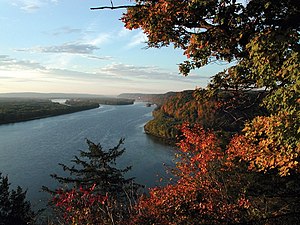
Mississippi River near Fire Point in Effigy Mounds National Monument, Iowa
| |
| Name origin: Ojibwe word misi-ziibi, meaning "Great River", or gichi-ziibi, meaning "Big River" | |
| দেশ | United States |
|---|---|
| প্ৰদেশসমূহ | Minnesota, Wisconsin, Iowa, Illinois, Missouri, Kentucky, Tennessee, Arkansas, Mississippi, Louisiana |
| উপনৈ | |
| - বাঁওদিশত | St. Croix River, Wisconsin River, Rock River, Illinois River, Kaskaskia River, Ohio River |
| - সোঁদিশত | Minnesota River, Des Moines River, Missouri River, White River, Arkansas River, Red River |
| চহৰসমূহ | Minneapolis, Saint Paul, Minnesota, La Crosse, Wisconsin, Quad Cities, IA/IL, St. Louis, MO, Memphis, Tennessee, Baton Rouge, LA, New Orleans LA |
| উৎস | Lake Itasca[1] |
| - অৱস্থান | Itasca State Park, Clearwater County, MN |
| - উচ্চতা | ১,৪৭৫ ফুট (৪৫০ মি) |
| - স্থানাঙ্ক | 47°14′23″N 95°12′27″W / 47.23972°N 95.2075°W |
| মোহনা | Gulf of Mexico |
| - অৱস্থান | Pilottown, Plaquemines Parish, LA |
| - উচ্চতা | ০ ফুট (০ মি) |
| - স্থানাঙ্ক | 29°09′04″N 89°15′12″W / 29.15111°N 89.25333°W |
| দৈৰ্ঘ্য | ২,৩২০ মাইল (৩,৭৩৪ কিমি) |
| অৱবাহিকা | ১১,৫১,০০০ বৰ্গমাইল (২৯,৮১,০৭৬ বৰ্গকিমি) |
| প্ৰবাহ | for mouth; max and min at Baton Rouge, LA |
| - গড় | ৫,৯৩,০০০ ঘনফুট/ছেকেণ্ড (১৬,৭৯২ ঘনমিটাৰ/ছেকেণ্ড) [2] |
| - সৰ্বোচ্চ | ৩০,৬৫,০০০ ঘনফুট/ছেকেণ্ড (৮৬,৭৯১ ঘনমিটাৰ/ছেকেণ্ড) |
| - সৰ্বনিম্ন | ১,৫৯,০০০ ঘনফুট/ছেকেণ্ড (৪,৫০২ ঘনমিটাৰ/ছেকেণ্ড) |
মিছিছিপি নদী উত্তৰ আমেৰিকা মহাদেশীয় অপবাহ প্ৰণালী (drainage system) ৰ প্ৰধান নদী৷[3][4] আমৰিকা যুক্তৰাষ্ট্ৰৰ ভিতৰতে মূলত: প্ৰবাহিত হোৱা এই নদী মিনোছ’টাৰ উত্তৰে উৎপত্তি হৈ দক্ষিণলৈ ২,৩২০ মাইল (3,730 km)[4] জুৰি বৈ গৈ Gulf of Mexico ৰ মিছিছিপি নদীৰ ব-দ্বীপ (Mississippi River Delta) ত পৰিছেগৈ৷ ইয়াৰ বিভিন্ন উপনৈসমূহৰ সৈতে মিলি আমেৰিকাৰ ৩১ খন ষ্টেট আৰু কানাডাৰ দুখন প্ৰদেশ বিয়পি আছে৷ মিছিছিপি নদী বিশ্বৰ চতুৰ্থ সৰ্বোচ্চ দৈৰ্ঘ্যৰ আৰু দশম বৃহৎ নদী হিচাপে স্বীকৃত ৷
ইতিহাস
[সম্পাদনা কৰক]নেটিভ আমেৰিকানসকলে পূৰ্বৰে পৰা মিছিছিপি নদী আৰু ইয়াৰ উপনৈসমূহৰ পাৰত বসবাস কৰি আহিছে৷ ইয়াৰে অধিকাংশই চিকাৰ বা পশুপালন কৰি জীৱন-নিৰ্বাহ কৰিছিল ৷ ১৫০০ চনলৈ ইউৰোপিয়ানসকলৰ আগমণে স্থানীয় জীৱন নিৰ্বাহৰ গতি সলাবলৈ আৰম্ভ কৰে ৷ প্ৰথমে ভ্ৰমণকাৰী, তাৰপিছত স্থায়ী বসতি আৰম্ভ কৰা এইলোকসকলৰ সংখ্যা মিছিছিপিৰ আশে পাশে বৃদ্ধি পাবলৈ ধৰে ৷ স্পেইন আৰু ফ্ৰান্সৰ সীমা নিৰ্ধাৰণ কৰা মিছিছিপি নদী তেওঁলোকৰ বাবে প্ৰথমাৱস্থাত বাধাৰূপে থিয় দিছিল যদিও পিছলৈ এই নদীয়ে জলপৰিবহণৰ প্ৰধান মাধ্যম হৈ পৰে ৷
গুৰুত্ব
[সম্পাদনা কৰক]নদীৰ গেদৰ ডাঠ প্ৰলেপেৰে গঠিত মিছিছিপিৰ উপত্যকা অঞ্চল অতিকে পলসুৱা ৷ আমেৰিকাৰ গৃহযুদ্ধৰ সময়ছোৱাত মিছিছিপিৰ মাজেৰে জলপৰিবহণ আৰু যোগাযোগে একত্ৰিত বাহিনী (Union forces) ৰ বিজয়ত এক বিশেষ ভূমিকা অৱলম্বন কৰিছিল ৷ শেহতীয়াকৈ এই উপত্যকাত মহানগৰ আৰু বন্দৰৰ দ্ৰুত বৃদ্ধিৰ ফলত বহুতো উদোগ তথা বান্ধৰো নিৰ্মাণ হৈছে৷
ভাবুকি
[সম্পাদনা কৰক]আধুনিক যুগত উদ্যোগীকৰণে মিছিছিপিৰ জলপ্ৰদূষণ আৰু প্ৰকৃতিৰ প্ৰতি এক ভাবুকিৰ সৃষ্টি কৰিছে ৷ এক বৃহৎ পৰিমাণৰ কৃষিৰ বৰ্জিত পদাৰ্থ (agricultural runoff) এই নদীত প্ৰতিবছৰে পৰেহি৷ গাল্ফ অব মেস্কিকোৰ মৃত অঞ্চল (Gulf of Mexico dead zone) সৃষ্টি হোৱাৰ ইয়ে মূল কাৰণ বুলি ধাৰণা কৰা হয়৷ শেহতীয়াকৈ মিছিছিপি নদীৰ গতিপথৰ লাহে লাহে পৰিৱৰ্ত্তন হোৱাৰ তথ্য পোৱা গৈছে৷ ইয়াৰ ফলত নিউ অৰলেনছৰ অৰ্থনীতিত বিৰূপ প্ৰভাৱ পৰাৰো আশংকা কৰা হৈছে ৷
আলোকচিত্ৰৰ ভঁৰাল
[সম্পাদনা কৰক]-
MODIS images showing the outflow of fresh water from the Mississippi (arrows) into the Gulf of Mexico (2004)
-
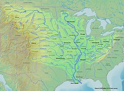
Map of the Mississippi River watershed
-
Lower Mississippi River near the city New Orleans
তথ্যসূত্ৰ
[সম্পাদনা কৰক]- ↑ The United States Geological Survey recognizes two contrasting definitions of a river's source.USGS.gov By the stricter definition, the Mississippi would share its source with its longest tributary, the Missouri, at Brower's Spring in Montana. The other definition acknowledges "somewhat arbitrary decisions" and places the Mississippi's source at Lake Itasca, which is publicly accepted as the source,USGS.gov and which had been identified as such by Brower himself.MT.gov Archived 2012-01-18 at the Wayback Machine
- ↑ Kammerer, J.C. (May 1990). "Largest Rivers in the United States". U.S. Geological Survey. http://pubs.usgs.gov/of/1987/ofr87-242/। আহৰণ কৰা হৈছে: February 22, 2011.
- ↑ United States Geological Survey Hydrological Unit Code: 08-09-01-00- Lower Mississippi-New Orleans Watershed
- ↑ 4.0 4.1 "Lengths of the major rivers". United States Geological Survey. http://ga.water.usgs.gov/edu/riversofworld.html। আহৰণ কৰা হৈছে: March 14, 2009.
লগতে চাওক
[সম্পাদনা কৰক]- Ambrose, Stephen. The Mississippi and the Making of a Nation: From the Louisiana Purchase to Today (National Geographical Society, 2002) heavily illustrated
- Anfinson, John O.; Thomas Madigan; Drew M. Forsberg; Patrick Nunnally (2003). The River of History: A Historic Resources Study of the Mississippi National River and Recreation Area. প্ৰকাশক St. Paul, MN: U.S. Army Corps of Engineers, St. Paul District. OCLC 53911450.
- Anfinson, John Ogden. Commerce and conservation on the Upper Mississippi Rvier (US Army Corps of Engineers, St. Paul District, 1994)
- Bartlett, Richard A. (1984). Rolling rivers: an encyclopedia of America's rivers. প্ৰকাশক New York: McGraw-Hill. ISBN 0-07-003910-0. OCLC 10807295.
- Botkin, Benjamin Albert. A Treasury of Mississippi River folklore: stories, ballads & traditions of the mid-American river country (1984).
- Carlander, Harriet Bell. A history of fish and fishing in the upper Mississippi River (PhD Diss. Iowa State College, 1954) online (PDF)
- Daniel, Pete. Deep'n as it come: The 1927 Mississippi River flood (University of Arkansas Press, 1977)
- Fremling, Calvin R. Immortal river: the Upper Mississippi in ancient and modern times (U. of Wisconsin Press, 2005), popular history
- Milner, George R. "The late prehistoric Cahokia cultural system of the Mississippi River valley: Foundations, florescence, and fragmentation." Journal of World Prehistory (1990) 4#1 pp: 1-43.
- Morris, Christopher. The Big Muddy: An Environmental History of the Mississippi and Its Peoples From Hernando de Soto to Hurricane Katrina (Oxford University Press; 2012) 300 pages; links drought, disease, and flooding to the impact of centuries of increasingly intense human manipulation of the river.
- Penn, James R. (2001). Rivers of the world: a social, geographical, and environmental sourcebook. প্ৰকাশক Santa Barbara, Calif.: ABC-CLIO. ISBN 1-57607-042-5. OCLC 260075679.
- Smith, Thomas Ruys (2007). River of dreams: imagining the Mississippi before Mark Twain. প্ৰকাশক Baton Rouge: Louisiana State University Press. ISBN 978-0-8071-3233-3. OCLC 182615621.
- Scott, Quinta (2010). The Mississippi: A Visual Biography. প্ৰকাশক Columbia, Missouri: University of Missouri Press. ISBN 978-0-8262-1840-7. OCLC 277196207.
- Pasquier, Michael (2013). Gods of the Mississippi. প্ৰকাশক Bloomington: Indiana University Press. ISBN 978-0-2530-0806-0.
বাহ্যিক সংযোগ
[সম্পাদনা কৰক]| ৱিকিমিডিয়া কমন্সত মিছিছিপি নদী সম্পৰ্কীয় মিডিয়া ফাইল আছে। |
| ৱিকিউৎসত মিছিছিপি নদী বিষয় সংক্ৰান্তীয় মূল পাঠ্য আছে। |
- Mississippi River Archived 2007-06-10 at the Wayback Machine, project of the American Land Conservancy
- Flood management in the Mississippi River
- Friends of the Mississippi River
- Mississippi National River and Recreation Area (MN) from the NPS
- Mississippi River Facts from the NPS
- "Mark Twain's Mississippi", from the digital library of Northern Illinois University
- Interactive detailed satellite photos and zoomable USGS topographic quad maps of the lower Mississippi, the alternative course for the river, and the various control structures and floodways Archived 2011-05-11 at the Wayback Machine
- Lower Mississippi Valley – Engineering Geology Mapping Program – PDF files of publications about and maps of the geology of the Mississippi River Valley and its tributaries.
- Ecoregions of the Mississippi Alluvial Plain Map
- "Old Man River Loses His Kinks" , April 1942, Popular Science article on 1930-40s project to improve barge navigation between Helena and Natchez
- এই চুটি চলচ্চিত্ৰখন "The River (1938)" ইণ্টাৰনেট আৰ্কাইভত বিনামূলীয়া ডাউনল’ডৰ বাবে উপলদ্ধ[অধিক]
- এই চুটি চলচ্চিত্ৰখন "The River (Part II) (1937)" ইণ্টাৰনেট আৰ্কাইভত বিনামূলীয়া ডাউনল’ডৰ বাবে উপলদ্ধ[অধিক]
- এই চুটি চলচ্চিত্ৰখন "The Valley of the Giant: Mississippi River story" ইণ্টাৰনেট আৰ্কাইভত বিনামূলীয়া ডাউনল’ডৰ বাবে উপলদ্ধ[অধিক]
 অপেন ষ্ট্ৰীট মেপত মিছিছিপি নদী বিষয়ক ভৌগোলিক তথ্য আছে।
- Roundtable discussion on Imagining the River, University of Minnesota, 2009 Archived 2013-01-17 at the Wayback Machine
- MRTIS - Mississippi River Traffic Information System


