
ভল্গা নদী: বিভিন্ন সংশোধনসমূহৰ মাজৰ পাৰ্থক্য
No edit summary |
|||
| 82 নং শাৰী: | 82 নং শাৰী: | ||
}} |
}} |
||
'''ভল্গা (Volga)''' ({{lang-rus|Во́лга|a=Ru-Волга.ogg|p=ˈvolɡə}}) নদী ইউৰোপ মহাদেশৰ আটাইতকৈ দীঘল নদী ৷ এই নদী [[ৰাছিয়া]]ৰ পৰা কেস্পিয়ান সাগৰলৈ বৈ গৈছে ৷ এই নদীক ৰাছিয়াৰ ৰাষ্ট্ৰীয় নদী (national river of Russia) বুলি গণ্য কৰা হয় ৷ |
'''ভল্গা (Volga)''' ({{lang-rus|Во́лга|a=Ru-Волга.ogg|p=ˈvolɡə}}) নদী ইউৰোপ মহাদেশৰ আটাইতকৈ দীঘল নদী ৷ এই নদী [[ৰাছিয়া]]ৰ পৰা কেস্পিয়ান সাগৰলৈ বৈ গৈছে ৷ এই নদীক ৰাছিয়াৰ ৰাষ্ট্ৰীয় নদী (national river of Russia) বুলি গণ্য কৰা হয় ৷ এই নদীয়ে ৰাছিয়াৰ সংস্কৃতিতো এক গুৰুত্বপূৰ্ণ স্থান অধিকাৰ কৰি আছে আৰু ৰাছিয়াৰ সাহিত্য তথা লোকপ্ৰবাদত এই নদীক ”Волга-матушка ''Volga-Matushka'' ” অৰ্থাৎ ভল্গা মাতৃ (Mother Volga) হিচাপে অভিহিত কৰা হয় ৷ |
||
Rising in the [[Valdai Hills]] {{convert|225|m|ft|sp=us}} [[Above mean sea level|above sea level]] northwest of [[Moscow]] and about {{convert|320|km|mi|sp=us}} southeast of [[Saint Petersburg]], the Volga heads east past [[Lake Sterzh]], [[Tver]], [[Dubna]], [[Rybinsk]], [[Yaroslavl]], [[Nizhny Novgorod]], and [[Kazan]]. From there it turns south, flows past [[Ulyanovsk]], [[Tolyatti]], [[Samara, Russia|Samara]], [[Saratov]] and [[Volgograd]], and discharges into the Caspian Sea below [[Astrakhan]] at {{convert|28|m|ft|sp=us}} below sea level. At its most strategic point, it bends toward the [[Don River, Russia|Don]] ("the big bend"). Volgograd, formerly Stalingrad, is located there. |
Rising in the [[Valdai Hills]] {{convert|225|m|ft|sp=us}} [[Above mean sea level|above sea level]] northwest of [[Moscow]] and about {{convert|320|km|mi|sp=us}} southeast of [[Saint Petersburg]], the Volga heads east past [[Lake Sterzh]], [[Tver]], [[Dubna]], [[Rybinsk]], [[Yaroslavl]], [[Nizhny Novgorod]], and [[Kazan]]. From there it turns south, flows past [[Ulyanovsk]], [[Tolyatti]], [[Samara, Russia|Samara]], [[Saratov]] and [[Volgograd]], and discharges into the Caspian Sea below [[Astrakhan]] at {{convert|28|m|ft|sp=us}} below sea level. At its most strategic point, it bends toward the [[Don River, Russia|Don]] ("the big bend"). Volgograd, formerly Stalingrad, is located there. |
||
22:53, 11 August 2015ৰ সংস্কৰণ
| ভল্গা নদী (Volga River) (Волга) | |
 ’Ulyanovsk’ ত ভল্গা নদী
| |
| দেশ | ৰাছিয়া |
|---|---|
| উপনৈ | |
| - বাঁওদিশত | Kama River |
| - সোঁদিশত | Oka River |
| চহৰসমূহ | Astrakhan, Volgograd, Saratov, Samara, Ulyanovsk, Kazan, Nizhny Novgorod, Yaroslavl, Tver |
| উৎস | |
| - অৱস্থান | Valdai Hills, Tver Oblast |
| - উচ্চতা | ২২৫ মি (৭৩৮ ফুট) |
| - স্থানাঙ্ক | 57°9′N 32°36′E / 57.15°N 32.6°E |
| মোহনা | কেস্পিয়ান সাগৰ |
| - উচ্চতা | −২৮ মি (−৯২ ফুট) |
| - স্থানাঙ্ক | 45°50′N 47°58′E / 45.833°N 47.967°E [1] |
| দৈৰ্ঘ্য | ৩,৬৯২ কিমি (২,২৯৪ মাইল) |
| অৱবাহিকা | ১৩,৮০,০০০ বৰ্গকিমি (৫,৩২,৮২১ বৰ্গমাইল) |
| প্ৰবাহ | for Astrakhan |
| - গড় | ৮,০৬০ ঘনমিটাৰ/ছেকেণ্ড (২,৮৪,৬৩৬ ঘনফুট/ছেকেণ্ড) |
 Map of the Volga watershed
| |
ভল্গা (Volga) (ৰুছ: Во́лга; IPA: [ˈvolɡə] (![]() শুনক)) নদী ইউৰোপ মহাদেশৰ আটাইতকৈ দীঘল নদী ৷ এই নদী ৰাছিয়াৰ পৰা কেস্পিয়ান সাগৰলৈ বৈ গৈছে ৷ এই নদীক ৰাছিয়াৰ ৰাষ্ট্ৰীয় নদী (national river of Russia) বুলি গণ্য কৰা হয় ৷ এই নদীয়ে ৰাছিয়াৰ সংস্কৃতিতো এক গুৰুত্বপূৰ্ণ স্থান অধিকাৰ কৰি আছে আৰু ৰাছিয়াৰ সাহিত্য তথা লোকপ্ৰবাদত এই নদীক ”Волга-матушка Volga-Matushka ” অৰ্থাৎ ভল্গা মাতৃ (Mother Volga) হিচাপে অভিহিত কৰা হয় ৷
শুনক)) নদী ইউৰোপ মহাদেশৰ আটাইতকৈ দীঘল নদী ৷ এই নদী ৰাছিয়াৰ পৰা কেস্পিয়ান সাগৰলৈ বৈ গৈছে ৷ এই নদীক ৰাছিয়াৰ ৰাষ্ট্ৰীয় নদী (national river of Russia) বুলি গণ্য কৰা হয় ৷ এই নদীয়ে ৰাছিয়াৰ সংস্কৃতিতো এক গুৰুত্বপূৰ্ণ স্থান অধিকাৰ কৰি আছে আৰু ৰাছিয়াৰ সাহিত্য তথা লোকপ্ৰবাদত এই নদীক ”Волга-матушка Volga-Matushka ” অৰ্থাৎ ভল্গা মাতৃ (Mother Volga) হিচাপে অভিহিত কৰা হয় ৷
Rising in the Valdai Hills ২২৫ মিটাৰ (738 ফুট) above sea level northwest of Moscow and about ৩২০ kilometer (200 মাইল) southeast of Saint Petersburg, the Volga heads east past Lake Sterzh, Tver, Dubna, Rybinsk, Yaroslavl, Nizhny Novgorod, and Kazan. From there it turns south, flows past Ulyanovsk, Tolyatti, Samara, Saratov and Volgograd, and discharges into the Caspian Sea below Astrakhan at ২৮ মিটাৰ (92 ফুট) below sea level. At its most strategic point, it bends toward the Don ("the big bend"). Volgograd, formerly Stalingrad, is located there.

The Volga has many tributaries, most importantly the Kama, the Oka, the Vetluga, and the Sura rivers. The Volga and its tributaries form the Volga river system, which flows through an area of about সাঁচ:Convert/LoffAnoneDbSoffসাঁচ:Convert/test/Aoff in the most heavily populated part of Russia. The Volga Delta has a length of about সাঁচ:Convert/LoffAnoneDbSoffসাঁচ:Convert/test/Aoff and includes as many as 500 channels and smaller rivers. The largest estuary in Europe, it is the only place in Russia where pelicans, flamingos, and lotuses may be found. The Volga freezes for most of its length for three months each year.
The Volga drains most of Western Russia. Its many large reservoirs provide irrigation and hydroelectric power. The Moscow Canal, the Volga–Don Canal, and the Volga–Baltic Waterway form navigable waterways connecting Moscow to the White Sea, the Baltic Sea, the Caspian Sea, the Sea of Azov and the Black Sea. High levels of chemical pollution have adversely affected the river and its habitats.
The fertile river valley provides large quantities of wheat, and also has many mineral riches. A substantial petroleum industry centers on the Volga valley. Other resources include natural gas, salt, and potash. The Volga Delta and the nearby Caspian Sea offer superb fishing grounds. Astrakhan, at the delta, is the center of the caviar industry.
ভল্গা নদীৰ ওপৰত থকা বান্ধ
A number of large hydroelectric reservoirs were constructed on the Volga during the Soviet era. They are:
- Volgograd Reservoir
- Saratov Reservoir
- Kuybyshev Reservoir-the largest in Europe by surface
- Cheboksary Reservoir
- Gorky Reservoir
- Rybinsk Reservoir
- Uglich Reservoir
- Ivankovo Reservoir
আলোকচিত্ৰ ভঁৰাল
-
 View of the river and Volgograd from space.
 -
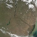
 Volga River delta, Terra
 -
 Terra/MODIS, 2002-05-17.
 -
 Terra/MODIS, 2001-10-10.
 -
 Rzhev is the uppermost town situated on the Volga (photographed c. 1910)
 -
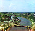
 A suspension bridge (Stariy Most/Старый Мост) across the Volga in Tver
 -
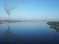 Nizhny Novgorod ৰ ওচৰত ভল্গা নদী


তথ্যসূত্ৰ
বাহ্যিক সংযোগ
- Volga Delta from Space
- Photos of the Volga coasts
 অপেন ষ্ট্ৰীট মেপত ভল্গা নদী বিষয়ক ভৌগোলিক তথ্য আছে।
- "Video about the source of Volga River". Missing or empty
|series=(help)