
য়াংজে নদী
| য়াংজে নদী (长江) | |
 য়ুনান প্ৰদেশত য়াংজে নদী
| |
| দেশ | |
|---|---|
| উপনৈ | |
| - বাঁওদিশত | Yalong, Min, Tuo, Jialing, Han |
| - সোঁদিশত | Wu, Yuan, Zi, Xiang, Gan, Huangpu |
| চহৰসমূহ | Yibin, Luzhou, Chongqing, Wanzhou, Yichang, Jingzhou, Yueyang, Wuhan, Jiujiang, Anqing, Tongling, Wuhu, Nanjing, Zhenjiang, Nantong, ছাংহাই |
| উৎস | Geladaindong Peak |
| - অৱস্থান | Tanggula Mountains, Qinghai |
| - উচ্চতা | ৫,০৪২ মি (১৬,৫৪২ ফুট) |
| - স্থানাঙ্ক | 33°25′44″N 91°10′57″E / 33.42889°N 91.1825°E |
| মোহনা | East China Sea |
| - অৱস্থান | ছাংহাই, আৰু জিয়াংচু |
| - স্থানাঙ্ক | 31°23′37″N 121°58′59″E / 31.39361°N 121.98306°E |
| দৈৰ্ঘ্য | ৬,৩০০ কিমি (৩,৯১৫ মাইল) [1] |
| অৱবাহিকা | ১৮,০৮,৫০০ বৰ্গকিমি (৬,৯৮,২৬৬ বৰ্গমাইল) [2] |
| প্ৰবাহ | |
| - গড় | ৩০,১৬৬ ঘনমিটাৰ/ছেকেণ্ড (১০,৬৫,৩০২ ঘনফুট/ছেকেণ্ড) [3] |
| - সৰ্বোচ্চ | ১,১০,০০০ ঘনমিটাৰ/ছেকেণ্ড (৩৮,৮৪,৬১৩ ঘনফুট/ছেকেণ্ড) [4][5] |
| - সৰ্বনিম্ন | ২,০০০ ঘনমিটাৰ/ছেকেণ্ড (৭০,৬২৯ ঘনফুট/ছেকেণ্ড) |
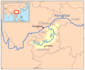
 The course of the Yangtze River through China
| |
য়াংজে নদী (Yangtze River) (ইংৰাজী ভাষাউচ্চাৰণ: /ˈjæŋtsi/ or /ˈjɑːŋtsi/), (Chinese: 长江, Cháng Jiāng), (চীনা নাম - Chang Jiang বা Yangzi) এছিয়াৰ আটাইতকৈ দীঘল আৰু বিশ্বৰ ভিতৰত তৃতীয় সৰ্বোচ্চ দৈৰ্ঘ্যৰ নদী। ’Qinghai-Tibet Plateau’ ৰ বৰফাবৃত অঞ্চলৰ পৰা দক্ষিণ-পশ্চিম, কেন্দ্ৰীয় আৰু পূব চীনৰ মাজেদি বৈ গৈ চাংহাইৰ পূব চীন সাগৰ (East China Sea) ত মিলিত হোৱালৈকে এই নদীয়ে প্ৰায় ৬,৩০০ কিলোমিটাৰ দুৰত্ব অতিক্ৰম কৰে। এই নদীয়ে চীনৰ এক-পঞ্চমাংশ অঞ্চলৰ পানীৰ প্ৰধান উৎস আৰু এই নৈৰ উপত্যকা চীনৰ এক-তৃতীয়াংশ জনসংখ্যাৰ বাসস্থান।[6]
এই নদীয়ে চীনৰ ইতিহাস, সংস্কৃতি আৰু অৰ্থনীতিত এক গুৰুত্বপূৰ্ণ স্থান দখল কৰি আছে। ইয়াৰ য়াংজে নদী ব-দ্বীপ ( Yangtze River Delta)-এ চীনৰ মূল জিডিপিৰ ২০% উৎপন্ন কৰে। এই নদী বিভিন্ন পৰিস্থিতিতন্ত্ৰৰ মাজেৰে প্ৰবাহিত হৈছে আৰু এই অঞ্চলসমূহ জৈব-বৈচিত্ৰ্যৰ ফালৰ পৰা অতি সমৃদ্ধ। সভ্যতাৰ আৰম্ভণিৰে পৰা এই নৈ উদ্যোগ, জলসিঞ্চন, পৰিবহণ, যুদ্ধ সকলো ক্ষেত্ৰতে ব্যৱহাৰ হৈ আহিছে। এই নৈৰ ওপৰত থকা ’Three Gorges Dam’ নামৰ নদীবান্ধটো বিশ্বৰ সৰ্ববৃহৎ হাইড্ৰ’ইলেকট্ৰিক পাৱাৰ ষ্টেচন ৰূপে স্বীকৃত।[7][8]
শেহতীয়াকৈ এই নদী ওদ্যোগিক প্ৰদূষণ, কৃষিক্ষেত্ৰৰ জাবৰৰ প্ৰদূষণ আদি ভাবুকিৰ সন্মুখীন হৈছে। এই নৈৰ পশ্চিম য়ুনানৰ অংশটো ইউনেস্ক’ৰ দ্বাৰা স্বীকৃতি প্ৰাপ্ত ৱৰ্ল্ড হেৰিটেজ ছাইট Three Parallel Rivers of Yunnan Protected Areas নামৰ সংৰক্ষিত বনাঞ্চলৰ অন্তৰ্ভুক্ত।[9]
নৈৰ পাৰত অৱস্থিত চহৰসমূহ
[সম্পাদনা কৰক]

- Panzhihua
- Yibin
- Fuzhou
- Chongqing
- Fengdu
- Yichang
- Jingzhou
- Shashi District
- Shishou
- Yueyang
- Xianning
- Wuhan
- Ezhou
- Huangshi
- Huanggang, Hubei
- Chizhou
- Jiujiang
- Anqing
- Tongling
- Wuhu City
- Hefei
- Chuzhou
- Ma'anshan
- Taizhou, Jiangsu
- Yangzhou]
- Zhenjiang
- Nanjing
- Jiangyin
- Nantong
- Shanghai
উপনৈ
[সম্পাদনা কৰক]
য়াংজে নৈৰ ৭০০ ৰো অধিক উপনৈ আছে বুলি জনা যায়। ইয়াৰ ভিতৰত মূল উপনৈ কেইখন হৈছে-
- Yalong River
- Min River (Sichuan)
- Tuo River
- Chishui River
- Jialing River
- Wu River
- Qing Jiang
- Yuan River
- Lishui River
- Zi River
- Xiang River
- Han River (Hanshui)
- Gan River (Jiangxi)
- Shuiyang River
- Qingyi River
- Chao Lake
- Tai Lake
আলোকচিত্ৰৰ ভঁৰাল
[সম্পাদনা কৰক]-
 য়াংজে নদীৰ ওপৰত প্ৰথমখন দলং ’Wuhan Yangtze River Bridge’ ৰ নিৰ্মাণ সম্পূৰ্ণ হৈ উঠে ১৯৫৭ চনত
 -
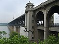
 য়াংজে নৈৰ ওপৰত ১৯৬৮ নিৰ্মাণ সম্পূৰ্ণ হৈ উঠা ’Nanjing Yangtze’ দলং
 -
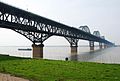 ১৯৯২ ত সম্পূৰ্ণ হোৱা ’Jiujiang Yangtze’ দলং
 -
 ১৯৯৬ চনত নিৰ্মাণ সম্পূৰ্ণ হোৱা Yichang Yangtze Highway Bridge নামৰ ওলোমা সেতুখন
 -
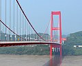
 Sutong Yangtze’ নামৰ দলংখন বিশ্বৰ ভিতৰতে আটাইতকৈ দীঘল cable-stayed দলং
 -
 TCaiyuanba দলং
 -
 Anqing Yangtze River Bridge দলং
 -
 য়াংজে নদীৰ উপনৈ Wu
 -
 য়াংজে নৈৰ উপনৈ জিয়ালিং নৈ (Jialing River)
 -
 মিন (Min River), য়াংজে নৈৰ উপনৈ
 -
![য়ালং নৈ (Yalong River),] য়াংজে নৈৰ উপনৈ](//upload.wikimedia.org/wikipedia/commons/thumb/1/15/Yalongrivermap.png/120px-Yalongrivermap.png) য়ালং নৈ (Yalong River),] য়াংজে নৈৰ উপনৈ
য়ালং নৈ (Yalong River),] য়াংজে নৈৰ উপনৈ


![য়ালং নৈ (Yalong River),] য়াংজে নৈৰ উপনৈ](/wiki/%E0%A6%9A%E0%A6%BF%E0%A6%A4%E0%A7%8D%E0%A7%B0:Yalongrivermap.png)
তথ্যসূত্ৰ
[সম্পাদনা কৰক]- ↑ Encyclopædia Britannica: Yangtze River http://www.britannica.com/eb/article-9110538/Yangtze-River
- ↑ Zhang Zengxin; Tao Hui; Zhang Qiang; Zhang Jinchi; Forher, Nicola; Hörmann, Georg. "Moisture budget variations in the Yangtze River Basin, China, and possible associations with large-scale circulation". Stochastic Environmental Research and Risk Assessment (Springer Berlin/Heidelberg) খণ্ড 24 (5): 579–589. doi:10.1007/s00477-009-0338-7.
- ↑ "Main Rivers". National Conditions. China.org.cn. http://china.org.cn/english/eng-shuzi2003/gq/dili5.htm। আহৰণ কৰা হৈছে: 2010-07-27.
- ↑ https://probeinternational.org/three-gorges-probe/flood-types-yangtze-river Archived 2011-07-23 at the Wayback Machine Accessed 2011-02-01
- ↑ "Three Gorges Says Yangtze River Flow Surpasses 1998". Bloomberg Businessweek. 2010-07-20. http://www.businessweek.com/news/2010-07-20/three-gorges-says-yangtze-river-flow-surpasses-1998.html। আহৰণ কৰা হৈছে: 2010-07-27.
- ↑ [1][সংযোগবিহীন উৎস]. Accessed 10 Sept 2010.
- ↑ "Three Gorges Dam, China : Image of the Day". earthobservatory.nasa.gov. http://earthobservatory.nasa.gov/IOTD/view.php?id=38879। আহৰণ কৰা হৈছে: 2009-11-03.
- ↑ International Rivers, Three Gorges Dam profile Archived 2009-04-20 at the Wayback Machine, Accessed August 3, 2009
- ↑ "New stimulus measures by China to boost economic growth". Beijing Bulletin. Archived from the original on 14 July 2014. https://web.archive.org/web/20140714231927/http://www.beijingbulletin.com/index.php/sid/222852671/scat/ce9cf98a4a863704/ht/New-stimulus-measures-by-China-to-boost-economic-growth। আহৰণ কৰা হৈছে: 12 June 2014.
লগতে চাওক
[সম্পাদনা কৰক]- Carles, William Richard, "The Yangtse Chiang", The Geographical Journal, Vol. 12, No. 3 (Sep., 1898), pp. 225–240; Published by: Blackwell Publishing on behalf of The Royal Geographical Society (with the Institute of British Geographers)
- Danielson, Eric N. 2004. Nanjing and the Lower Yangzi, From Past to Present, The New Yangzi River Trilogy, Vol. II. Singapore: Times Editions/Marshall Cavendish. ISBN 981-232-598-0.
- Danielson, Eric N. 2005. The Three Gorges and The Upper Yangzi, From Past to Present, The New Yangzi River Trilogy, Vol. III. Singapore: Times Editions/Marshall Cavendish. ISBN 981-232-599-9.
- Grover, David H. 1992 American Merchant Ships on the Yangtze, 1920-1941. Wesport, Conn.: Praeger Publishers.
- Van Slyke, Lyman P. 1988. Yangtze: nature, history, and the river. A Portable Stanford Book. ISBN 0-201-08894-0
- Winchester, Simon. 1996. The River at the Center of the World: A Journey Up the Yangtze and Back in Chinese Time, Holt, Henry & Company, 1996, hardcover, ISBN 0-8050-3888-4; trade paperback, Owl Publishing, 1997, ISBN 0-8050-5508-8; trade paperback, St. Martins, 2004, 432 pages, ISBN 0-312-42337-3
বাহ্যিক সংযোগ
[সম্পাদনা কৰক]| ৱিকিমিডিয়া কমন্সত Yangtze River (Chang Jiang) সম্পৰ্কীয় মিডিয়া ফাইল আছে। |
![]() অপেন ষ্ট্ৰীট মেপত য়াংজে নদী বিষয়ক ভৌগোলিক তথ্য আছে।
অপেন ষ্ট্ৰীট মেপত য়াংজে নদী বিষয়ক ভৌগোলিক তথ্য আছে।
- Yangtze Three Gorges Gallery Archived 2016-02-19 at the Wayback Machine
- Yangtze river gallery